![]()
![]()
![]()
Use LEFT and RIGHT arrow keys to navigate between flashcards;
Use UP and DOWN arrow keys to flip the card;
H to show hint;
A reads text to speech;
18 Cards in this Set
- Front
- Back
|
Teacher had a conference at the __ near ski resort. |
Basin and Range Province in Las Vegas |
|
|
Guess who is running precariously low on water?
|
Hoover Dam & Lake Mead |
|
|
Hoover Dam & Lake Mead suffer from the ___ which is when each increment down represents less and less fluid because the areas and volumes become smaller. ON TEST FOR SURE. |
The Martini glass effect. This is because it the dams are shaped like Martini glasses. |
|
|
Basin and Range with ___ Valley as Type Analog
|
Death Valley |
|
|
The Basin and Range is between ___ and ___. |
Sierra Nevada & Salt Lake City |
|
|
Western North America is a TOPOGRAPHIC __. The Basin & Range is a topographically ___ place. Very active too. ON TEST FOR SURE.
|
High; Hot |
|
|
Basin and Range Landscape has subparallel ___ and linear ___.
|
mountains and valleys
|
|
|
___ tectonics in the Basin & Range area. There are natural faults, but also THINS out so it creates faults, but it thin it out. |
Extensional tectonics |
|
|
Basin & Range has high __ flow. __ is happening in the Pacific and the Atlantic, but the Atlantic is on steroids with its own so it's pushing the North American boundary closer even though has it too. It's making it move up and down. (how it's making the basin & range) |
heat; Divergence; |
|
|
East of U.S. has __ heat flow. West of rockies has __ heat flow. We overrode divergent boundary here. |
low; high; |
|
|
The Basin and range is highly concentrated by __ faults, but has __ faults too. __ faults thought to accommodate motion of the plates. |
Normal faults; Lateral faults; Lateral faults; |
|
|
Basin and Range is very active. This place is ROCKING with __ activity.
Ex. __ Valley, March 1872 estimated at 7.8. Shifted block 1-2 meters vertically and 6 meters horizontally. __ Valley Nevada, 1954, shifted block 5 meters |
earthquake; Owen's Valley and Dixie Valley; |
|
|
Unusual Volcano associations in Basin. __ volcanic field near Owens Valley. Inflating crust & faulting & extenstion thinning the crust gives lots of heat so basalt rises up to produce volcanoes. Enough heat flow & water to get ____ in proximity (Rhyolite near Basalt). Rare occurrences of lower crust and upper mantle xeonliths have come up to the surface through volcanos in cindercones at __ and __ volcanic field
|
Coso volcanic field; Bimodal rock magma types; Dish Hill & Cima Volcanic field; |
|
|
__ is a break in the topography caused by surface faulting. Forms when an earthquake ruptures the ground surface, dispacing the landscape along a sharp break. |
fault scrap |
|
|
Many normal faults are steep at surface, but shallow at depth. Sometimes the roots break off. These are ___. Normal faults are part of ___ (same answer as before). They detach from what's beneath. |
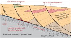
Detachment faults |
|
|
Detachment faults are significant in that they appear to connect to the bottom portions of normal faults and allow the overlying blocks to __. This helps accommodate the stress/strain of extension. |
rotate; |
|
|
Divergent margin gets sucked into the divergent zone. Basin and range is compared to what? |
Rising Bread dough analogy |
|
|
The earth’s crust does not behave like breaddough because it __ instead of just stretches but image how the earth’s crust has to thin as it inflates and expands laterally. |
faults; |