![]()
![]()
![]()
Use LEFT and RIGHT arrow keys to navigate between flashcards;
Use UP and DOWN arrow keys to flip the card;
H to show hint;
A reads text to speech;
10 Cards in this Set
- Front
- Back
|
Vector Data Types
|
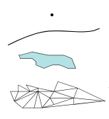
0 dimensions - points
1 " - Lines 2 " - Polygons 3 " - Triangulated networks |
|
|
Vector Data Representation |
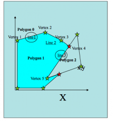
Series of linked tables recording vertex (point), line and polygon data |
|
|
Raster Data |
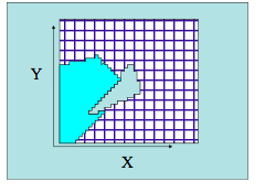
INDEX NUMBER attributed to each CELL & TABLE OF ATTRIBUTES for each INDEX NUMBER |
|
|
Georeferencing or Registration |
Give an object correct geographic coordinates. |
|
|
Map Projection =translation of curved earth's surface to flat map projection. |
Involves: -Projection TYPE - UTM, Lambert Conformal Conic etc -Map ZONE -i.e. SH55- or bounding meridians and lines of latitude -DATUM - based on shape of geoid at location, + origin (centre of earth's mass) -grid UNITS i.e. meters, yard, kms |
|
|
Latitude |
Measured as an ANGLE from the Earth's center. North or South (negative) of the equator '0°' to the poles '90°' 1° = 111km everywhere |
|
|
Longitude |
Measured from 0° (Royal Greenwich Observatory) in Easterly and Westerly direction, until they meet at 180°. 1° = 111km at the equator, 0kms at the poles Lines of longitude converge at rotational poles (True North and South) |
|
|
3 Types of North |
Grid North Rotational North Magnetic North |
|
|
Universal Transverse Mercator (UTM) Projection |
nato utm and general utm - good n bad about it |
|
|
Cartesian coordinates |
Based on a regular grid. Measured in DISTANCE UNITS i.e. kms or meters, which are uniform across a mapped area. Allow robust spatial analysis - between coordinates you can tell accurate distance |