![]()
![]()
![]()
Use LEFT and RIGHT arrow keys to navigate between flashcards;
Use UP and DOWN arrow keys to flip the card;
H to show hint;
A reads text to speech;
49 Cards in this Set
- Front
- Back
|
Legal Description |
A description of a specific parcel of real estate complete enough for an independent surveyor to locate and identify it. |
|
|
Survey |
The process by which boundaries are measured and land areas are determined; the on-site measurement of lot lines, dimensions, and position of a house on a lot, including the determination of any existing encroachments or easements. |
|
|
3 methods to legally describe land (real estate) |
• Metes and bounds • Rectangular (or government) survey • Lot and block (recorded plat) |
|
|
GIS |
geographic information system |
|
|
CAD |
computer-assisted design |
|
|
NILS |
National Integrated Land System |
|
|
metes-and-bounds method |
method relies on a property's physical features to determine the boundaries and measurements of the parcel *metes - measure *bounds - linear direction |
|
|
Point Of Beginning (POB) |
metes-and-bounds description starts at a designated place on the parcel. The description always ends back at the POB |
|
|
monuments |
A fixed natural or artificial object used to establish real estate boundaries for a metes-and-bounds description. |
|
|
Rectangular (government) Survey System |
A system established in 1785 by the federal government, providing for surveying and describing land by reference to principal meridians and base lines. |
|
|
principal meridians |
run north and south, |
|
|
base lines |
run east and west |
|
|
Point Of Beginning (POB) |
metes-and-bounds description starts at a designated place on the parcel. The description always ends back at the POB |
|
|
base lines |
run east and west |
|
|
Township Lines |
All the lines in a rectangular survey system that run east and west, parallel to the base line and six miles apart. |
|
|
Tiers |
Strips of land that are six miles wide, extending east and west and numbered north and south according to their distance from the base line in the rectangular (government) survey system of legal description. |
|
|
Range |
A strip of land six miles wide, extending north and south and numbered east and west according to its distance from the principal meridian in the rectangular (government) survey system of legal description. |
|
|
Township |
The principal unit of the rectangular (government) survey system. A township is a 6-mile square of 36 square miles. |
|
|
Section |
A portion of a township under the rectangular (government) survey system. A township is divided into 36 sections, numbered 1 through 36. A section is a square with mile-long sides and an area of one square mile, or 640 acres. |
|
|
Lot-and-block (recorded Plat) Method |
A method of describing real property that identifies a parcel of land by reference to lot and block numbers within a subdivision, as specified on a recorded subdivision plat. |
|
|
Plat Map |
A map of a town, section, or subdivision indicating the location and boundaries of individual properties. |
|
|
Air Lots |
Designated airspace over a piece of land. An air lot, like surface property, may be transferred. |
|
|
Datum |
A horizontal plane from which heights and depths are measured. |
|
|
Benchmarks |
Permanent reference marks or points established for use by surveyors in measuring differences in elevation. |
|
|
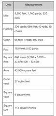
Units of Land Measurement |
Back (Definition) |
|
|
The most common units of land measurement include the |
•mile of 5,280 feet, •acre of 43,560 square feet (approximately 209 × 209 feet), and •square mile of 640 acres (a section). |
|
|
To integrate information found in publicly available land records, the Federal Geographic Data Committee has created: |
the Cadastral Data Content Standard |
|
|
Which is the process by which boundaries are measured by calculating the dimensions and area to determine the exact location of a piece of land? |
Survey |