![]()
![]()
![]()
Use LEFT and RIGHT arrow keys to navigate between flashcards;
Use UP and DOWN arrow keys to flip the card;
H to show hint;
A reads text to speech;
374 Cards in this Set
- Front
- Back
- 3rd side (hint)
|
1-1 On a weather map, cold fronts are indicated by ________ symbols and warm fronts by _______ symbols. a. dark, light b. triangle, semicircle c. circle, triangle d. semicircle, triangle |
b. triangle, semicircle |
|
|
|
1-2 To represent a warm or cold front on a
weather map, the appropriate symbol is drawn on the side toward which a. the wind is blowing b. the center of low pressure is located c. the front is moving d. the air is colder |
c. the front is moving
|
|
|
|
1-3 If triangles and semicircles are shown on opposite
sides of the same frontal boundary, the front is a. cold b. occluded c. stationary d. warm |
c. stationary
|
|
|
|
1-4 Near a cold front, ______ air is advancing
and replacing the ______ air on the other side. a. cold, warm b. cloudy, clear c. moist, dry d. windy, calm |
a. cold, warm
|
|
|
|
1-5 The approach of deteriorating weather is indicated
by a a. falling hygrometer b. rising barometer c. falling barometer d. falling speedometer |
c. falling barometer
|
|
|
|
1-6 For best results, an outdoor thermometer
should be a. bought from a hardware store b. mounted in a shady spot c. filled with colored water d. read on cloudy days |
b. mounted in a shady spot
|
|
|
|
1-7 Humidity is measured by an instrument
called a/an a. atomizer b. humidifier c. hygrometer d. moisturizer |
c. hygrometer
|
|
|
|
1-8 The amount of moisture actually in the air, as
a _______ of what the air could contain, is called the _______ humidity. a. ratio, measured b. percentage, relative c. fraction, atmospheric d. percentage, partial |
b. percentage, relative
|
|
|
|
1-9 The maximum amount of moisture air can
contain _______ as the air temperature ______. a. decreases, decreases b. increases, decreases c. decreases, increases d. stays the same, increases |
a. decreases, decreases
|
|
|
|
1-10 Increasing wind speed is a sign that a
_______ is _______ . a. high, approaching b. front, departing c. front, approaching d. low, receding |
c. front, approaching
|
|
|
|
1-11 A north wind blows from the compass direction
a. 360 or 000 b. 270 c. 180 d. 090 |
a. 360 or 000
|
|
|
|
1-12 If the wind changes direction from 240 to
280 degrees, it is said to be a. backing b. gusting c. turning d. veering |
d. veering
|
|
|
|
1-13 You are facing NE, and the wind is at your
back. According to the Buys Ballot rule, there is lower pressure a. to the SE b. to the SW c. to your left d. behind you |
c. to your left
|
|
|
|
1-14 Clouds of the _______ form indicate that
there is little or no vertical motion of the air, whereas clouds of the _______ form indicate that up- and down-drafts are present. a. cumulus, stratus b. stratus, nimbus c. stratus, cumulus d. stratus, cirrus |
c. stratus, cumulus
|
|
|
|
1-15 Clouds are divided into ______ , ______ ,
and ______ families according to the heights of their bases. a. high, middle, low b. low, high, extensive vertical development c. stratus, cumulus, cirrus d. high, low, surface |
a. high, middle, low
|
|
|
|
1-16 Clouds of extensive vertical development
include a. stratocumulus and cumulonimbus b. towering cumulus and nimbostratus c. towering cumulus and cumulonimbus d. nimbostratus and cumulonimbus |
c. towering cumulus and cumulonimbus
|
|
|
|
1-17 The prefix “nimbo-” or suffix “-nimbus” is
attached to a cloud form when it is a. dissipating b. lowering c. raining d. thickening |
c. raining
|
|
|
|
1-18 An approaching cold front would be ind icated
by ______ , ______, and ______ clouds. a. cirrus, cirrocumulus, altocumulus b. cirrus, cirrostratus, altostratus c. cirrus, cirrocumulus, nimbostratus d. altocumulus, cirrocumulus, cirrus |
a. cirrus, cirrocumulus, altocumulus
|
|
|
|
2-1 The most important cause of weather is
a. gravity b. latent heat of condensation c. uneven solar heating d. regions of high and low pressure |
c. uneven solar heating
|
|
|
|
2-2 Winds generally blow
a. during daytime b. toward areas of low pressure c. toward areas of high pressure d. toward areas of low density |
b. toward areas of low pressure
|
|
|
|
2-3 Half the water vapor in the atmosphere is
found a. above the dew point b. below the troposphere c. below the tropopause d. below 6,500 feet above sea level |
d. below 6,500 feet above sea
|
|
|
|
2-4 The proportions of dry constituents in the
atmosphere a. are always the same b. decrease as moisture increases c. vary with density d. vary with temperature |
a. are always the same
|
|
|
|
2-5 Density is the ______ of a substance divided
by its ______. a. pressure, area b. weight, volume c. weight, area d. pressure, volume |
b. weight, volume
|
|
|
|
2-6 A temperature of 77 oF is equal to ___ oC.
a. 11 b. 25 c. 61 d. 75 |
b. 25
|
|
|
|
2-7 A temperature of 35 oC is equal to ___ oF.
a. 31 b. 51 c. 95 d. 121 |
c. 95
|
|
|
|
2-8 Which of the following statements are true?
a. A quart of air at 70 oF contains less heat than a quart of water at 70 oF. b. A pint of air at 70 oF contains less heat than a quart of air at 70 oF. c. A quart of air at 50 oF contains less heat than a quart of air at 70 oF. d. All of the above |
d. All of the above
|
|
|
|
2-9 Pressure is proportional to the product of
a. absolute temperature and density b. temperature and absolute density c. temperature and absolute humidity d. absolute temperature and humidity |
a. absolute temperature and density
|
|
|
|
2-10 Which is heavier, a pound of air or a pound
of iron? a. The air b. The iron c. Neither, they have the same density d. Neither, but the iron is more dense |
d. Neither, but the iron is more dense
|
|
|
|
3-1 A convective current transports _____ by
means of ________. a. temperature, heat exchange b. heat, conduction c. heat, material exchange d. radiation, transfer |
c. heat, material exchange [25]
|
|
|
|
_________ heat.
a. latent b. molecular c. sensible d. sensitive |
c. sensible [25]
|
|
|
|
3-3 Rising moist air transports both sensible and
_______ heat. a. advective b. infrared c. latent d. vaporous |
c. latent [25]
|
|
|
|
3-4 A wind blowing warm air from the south toward
colder air to the north is transporting heat by means of a. advection b. conduction c. convection d. radiation |
a. advection [25, 26]
|
|
|
|
3-5 When sunshine strikes the earth’s surface, a
layer of soil below the surface is warmed by a. advection b. conduction c. convection d. radiation |
b. conduction [26]
|
|
|
|
3-6 At night, the temperature of a soil layer will
decrease faster than the temperature of an ocean water layer because a. there is no solar radiation at night b. the surfaces emit infrared to the atmosphere c. the soil heat capacity is greater d. the soil heat capacity is lower |
d. the soil heat capacity is lower [26]
|
|
|
|
3-7 Warm land and water surfaces radiate heat to
the atmosphere at ______ wavelengths. a. infrared b. radio c. ultraviolet d. visible |
a. infrared [26]
|
|
|
|
3-8 Heat from the sun is ultimately returned to
space by mainly means of a. reflected ultraviolet radiation b. infrared radiation c. advection and convection d. sublimation |
b. infrared radiation [27]
|
|
|
|
3-9 Convection in the atmosphere occurs when
______ warms the ______ . a. ultraviolet, ozone layer b. latent heat, troposphere c. solar radiation, surface d. sensible heat, tropopause |
c. solar radiation, surface [28]
|
|
|
|
3-10 The standard atmosphere temperature at an
altitude of ten thousand feet is a. – 16 oC b. – 5 oC c. +39 oC d. +39 oF |
b. – 5 °C [28]
|
|
|
|
3-11 The three factors which cause deviations
from the global average heat balance are: a. advection, diurnal, and seasonal b. diurnal, latitude, and longitude c. latitude, seasonal, and diurnal d. latitude, longitude, and convection |
c. latitude, seasonal, and diurnal [28]
|
|
|
|
3-12 Diurnal variation means that the earth
______ heat during the day and ______ heat during the night. a. absorbs, advects b. gains, loses c. absorbs, emits d. gains, reflects |
b. gains, loses [28]
|
|
|
|
3-13 The earth’s surface temperature is generally
coldest a. just after sundown b. at midnight c. just before dawn d. just after dawn |
d. just after dawn [28]
|
|
|
|
3-14 The earth emits infrared radiation
a. all the time b. only at night c. only during the day d. only from the tropics |
a. all the time [29]
|
|
|
|
3-15 Atmospheric convection not associated with |
c. in the afternoon [29] |
|
|
|
3-16 Seasonal variation of solar heating is caused
by the earth’s ______ and ______ . a. atmosphere, axial tilt b. axial tilt, orbit around the sun c. orbit, latitude d. axial tilt, latitude |
b. axial tilt, orbit around the sun [29]
|
|
|
|
3-17 Latitude variation of solar heating is a result of differences in ______ and ______ . a. the earth’s axial tilt, the earth’s orbit b. axial tilt, sun angle c. sun angle, distance rays must travel through the atmosphere d. the earth’s orbit, distance rays must travel through the atmosphere |
c. sun angle, distance rays must travel through the atmosphere [29, 30] |
|
|
|
3-18 Blustery winter weather is a result of
a. seasonal variation causing strong advection b. large latitude variation of solar heating c. distance the sun’s rays must travel through the atmosphere d. low sun angle |
b. large latitude variation of solar heating [30]
|
|
|
|
3-19 Atmospheric water vapor will condense
a. as soon as the air cools to its dew point b. between the dew point and 0oC c. below 0oC d. below 0oF |
b. between the dew point and 0°C [30]
|
|
|
|
3-20 Ice crystals may form when moist air
a. cools to below the freezing point b. cools to its dew point c. becomes saturated d. encounters clouds |
a. cools to below the freezing point [30, 31]
|
|
|
|
3-21 ______ is especially dangerous if encountered
by vessels or aircraft. a. snow b. sleet c. ice pellets d. freezing rain |
d. freezing rain [31]
|
|
|
|
4-1 ______ are the atmosphere’s way of trying to |
c. Prevailing winds [35] |
|
|
|
4-2 Hadley’s theory provides the useful insight
that air tends to rise where ______ and descend where they ______ . a. surface winds converge, diverge b. surface winds diverge, converge c. winds aloft converge, diverge d. winds aloft diverge, converge |
a. surface winds converge, diverge [35
|
|
|
|
4-3 ______ is the main reason why global circulation
of the atmosphere is different from Hadley’s single-cell theory. a. Friction b. Gravity c. Rotation d. Uneven solar heating |
c. Rotation [36]
|
|
|
|
4-4 When an object traveling in a straight line
appears to follow a curved path because you are rotating while you observe it, the apparent motion is called the a. convergence b. Coriolis effect c. Coriolis force d. divergence |
b. Coriolis effect [36]
|
|
|
|
4-5 Your horizon circle on the earth’s surface
always has some rotation about the local vertical except at a. the equator b. mid- latitudes c. the poles d. the rotation axis |
a. the equator [37]
|
|
|
|
4-6 Horizon circle rotation explains why an observer |
c. northerly [37] |
|
|
|
4-7 ______ force refers to the force exerted by a
body moving in a circle and is directed ______ from the ______ . a. Centrifugal, inward, body b. Pressure gradient, outward, center c. Gravity, inward, earth d. Centrifugal, outward, axis of rotation |
d. Centrifugal, outward, axis of rotation [37, 38]
|
|
|
|
4-8 ______ winds follow a curved track to the
south in the northern hemisphere due to ______ . a. Easterly, decreased centrifugal force b. Westerly, increased gravitational force c. Westerly, increased centrifugal force d. Westerly, increased pressure gradient |
c. Westerly, increased centrifugal force [38]
|
|
|
|
4-9 The Coriolis effect is strongest at ______ and
disappears at ______. a. the equator, the poles b. the poles, the equator c. mid- latitudes, the equator d. mid- latitudes, the poles |
b. the poles, the equator [37, 38]
|
|
|
|
4-10 The ______ and the ______ are semipermanent
pressure belt features that have a significant effect on continental US weather. a. Aleutian low, Bermuda triangle b. ITCZ, trade winds c. Pacific high, Bermuda high d. Aleutian low, Icelandic low |
c. Pacific high, Bermuda high [39]
|
|
|
|
4-11 The ______ and the ______ are separated
by a belt of light and variable winds called the ______ . a. trade winds, westerlies, horse latitudes b. trade winds, westerlies, doldrums c. trade winds, westerlies, ITCZ d. NE, SE trade winds, horse latitudes |
a. trade winds, westerlies, horse latitudes [40]
|
|
|
|
4-12 The subtropical and polar jet streams are
high-speed “rivers” of air found near a. latitudes 60S and 60N b. 30 S and 30 N c. latitudes 30 and 60 d. the doldrums and the horse latitudes |
c. latitudes 30 and 60 [40]
|
|
|
|
4-13 As a general rule, air moving into an area of
low pressure tends to ______ , and air moving into an area of high pressure tends to ______ . a. rise, descend b. slow down, speed up c. descend, rise d. speed up, slow down |
a. rise, descend [41
|
|
|
|
4-14 The force of friction on a westerly jet
stream is directed toward the a. north b. east c. south d. west |
d. west [42]
|
|
|
|
4-15 The force of friction on winds in the atmosphere
becomes negligible in comparison with other forces a. at the surface b. at a height of 3,000 feet above the surface c. at altitudes above 3,000 feet d. in the horse latitudes and the doldrums |
b. at a height of 3,000 feet above the surface [42]
|
|
|
|
4-16 Forces affecting the wind are vectors, i.e.,
they possess a. velocity and speed b. direction and velocity c. magnitude and direction d. none of the above |
c. magnitude and direction [38
|
|
|
|
4-17 Steady winds tend to blow parallel to the
isobars when the effects of ______ and ______ are negligible. a. local and global rotation b. friction and Coriolis c. local rotation and friction d. pressure gradient and centrifugal force |
c. local rotation and friction [42]
|
|
|
|
4-18 Winds affected by friction blow
a. across the isobars from low to high pressure b. across the isobars from high to low pressure c. at right angles to the isobars d. parallel to the isobars |
b. across the isobars from high to low pressure [42]
|
|
|
|
4-19 Assuming all other things equal, the highest
wind speed should be expected where the isobars a. are straight b. are parallel c. form a ridge d. form a trough |
c. form a ridge [43]
|
|
|
|
4-20 A large amount of cold air is advected to
warmer regions and/or vice versa when Rossby waves have large a. amplitudes b. numbers c. pressures d. wavelengths |
a. amplitudes [44]
|
|
|
|
5-1 Besides the global and micro scales, meteorologists
classify weather patterns of different sizes as a. large and small b. synergistic and mesoscale c. synoptic and mesoscale d. mesoscale and molecular scale |
c. synoptic and mesoscale [49]
|
|
|
|
5-2 Synoptic scale features include
a. air masses and circulation around highs b. fronts and trade winds c. land and sea breezes d. mesoscale and microscale phenomena |
a. air masses and circulation around highs [49]
|
|
|
|
5-3 An air mass is a pool of air with ______
properties over a wide ______ . a. nearly chaotic, geographic area b. almost uniform, geographic area c. nearly uniform, altitude range d. the same, range of moisture content |
b. almost uniform, geographic area [49]
|
|
|
|
5-4 An air mass takes on its properties from the
underlying surface, which is called a a. continent b. ocean c. pool region d. source region |
d. source region [49, 50]
|
|
|
|
5-5 The two main characteristics used to classify
an air mass are a. continental and maritime b. moisture content and temperature c. polar and tropical d. pressure and temperature |
b. moisture content and temperature [50]
|
|
|
|
5-6 Air masses generally form in ______ and
migrate with ______ . a. highs, lows b. lows, highs c. pools, highs d. source regions, highs |
a. highs, lows [50]
|
|
|
|
5-7 ______ is likely to occur when an air mass
moves over a large body of warm water. a. Addition of moisture b. Cooling from below c. Orographic lift d. Removal of moisture |
a. Addition of moisture [50]
|
|
|
|
5-8 An air mass may become saturated, forming
clouds or fog, when a. it moves over a colder surface b. moisture is added c. both of the above d. none of the above |
c. both of the above [50]
|
|
|
|
5-9 Orographic lift promotes the ______ an air
mass. a. addition of heat to b. addition of moisture to c. removal of heat from d. removal of moisture from |
d. removal of moisture from [51]
|
|
|
|
5-10 A front is defined as warm or cold according
to a. whether the air masses are tropical or polar b. whether it is moving southward or eastward c. which air mass is advancing d. none of the above |
c. which air mass is advancing [52]
|
|
|
|
5-11 Near a stationary front, the tendency is for
a. calm conditions in all cases b. clouds to become stratiform c. winds to blow across the frontal boundary d. both air masses to advance |
b. clouds to become stratiform [52]
|
|
|
|
5-12 An occlusion occurs when a ______ front
overtakes a ______ front. a. warm, cold b. warm, cool c. cold, stationary d. cold, warm |
d. cold, warm [53]
|
|
|
|
5-13 Near a warm occlusion, the ______ air
mass is advancing, and the ______ air mass is retreating. a. cold, warm b. warm, cool c. cool, warm d. cool, cold |
d. cool, cold [53]
|
|
|
|
5-14 The boundary between two air masses with
similar pressure and temperature but different moisture content is called a a. dry front b. dry line c. dry occlusion d. twilight zone |
b. dry line [54]
|
|
|
|
5-15 One way in which a synoptic scale low can
form is by advection of warm air toward cold air a. to the east of a Rossby wave ridge b. to the east of a Rossby wave trough c. to the north of a Rossby wave ridge d. to the north of a Rossby wave trough |
b. to the east of a Rossby wave trough [55]
|
|
|
|
5-16 In the northern hemisphere, synoptic scale
circulation is ______ around lows and ______ around highs. a. clockwise, clockwise b. clockwise, counterclockwise c. counterclockwise, clockwise d. counterclockwise, counterclockwise |
c. counterclockwise, clockwise [55, 56]
|
|
|
|
5-17 At ______ altitudes, where surface friction
affects the wind, synoptic scale circulation takes the form of a ______ pattern. a. low, spiral b. high, spiral c. low, circular d. high, circular |
a. low, spiral [55, 56]
|
|
|
|
5-18 ______ may develop repeatedly and generate
a series of lows along a stationary front. a. hills and valleys b. ridges c. troughs d. waves |
d. waves [56]
|
|
|
|
5-19 Intensification describes the ______ .
a. decrease of central pressure in a low b. increase of central pressure in a low c. decrease of central pressure in a high d. increase of the size of a high |
a. decrease of central pressure in a low [57]
|
|
|
|
5-20 As compared to situations where there is
little or no geographic variation of air temperature, ______ tend to be more persistent and to generate worse weather. a. cold core highs b. cold core lows c. warm core highs d. warm core lows |
b. cold core lows [57, 58]
|
|
|
|
5-21 As a low approaches from the west, the
wind tends to ______ if the track of the low is to your north and to ______ if the track is to your south. a. back, veer b. veer, gust c. back, swing to the right d. veer, swing to the left |
d. veer, swing to the left [59]
|
|
|
|
5-22 If fog is predicted in the weather forecast,
you should expect the surface visibility to be a. 5/8 mile or less b. more than 5/8 mile c. between 5/8 mile and 2 miles d. between 5/8 mile and 6 miles |
a. 5/8 mile or less [59]
|
|
|
|
5-23 Haze is a restriction of visibility that may
be caused by ______ . a. mist or water droplets b. saturation or pollution particles c. water vapor or saturation d. water vapor or pollution particles |
d. water vapor or pollution particles [59]
|
|
|
|
5-24 The two most common types of fog are advection
fog and a. mist b. radiation fog c. steam fog d. up-slope fog |
b. radiation fog [60]
|
|
|
|
5-25 Advection fog
a. can be dispersed by a 5-knot wind b. forms overnight when the sky is clear c. may persist for days d. occurs as a thin, patchy layer |
c. may persist for days [60]
|
|
|
|
5-26 The primary weather feature that creates
ocean waves is a. atmospheric pressure b. friction c. gravity d. wind |
d. wind [60]
|
|
|
|
5-27 As compared with the actual forward motion
of water, a wave travels at a speed that is a. dependent on the atmospheric density b. equal c. faster d. slower |
c. faster [61]
|
|
|
|
5-28 As compared with the waves from which
they originated, swells a. are steeper b. tend to have longer wavelengths c. stop propagating when the wind dies d. all of the above |
c. b. tend to have longer wavelengths
|
|
|
|
5-29 If the height of the swell is 6 feet, the surf
zone should be expected to ______ where the depth of the water is about ______ feet. a. begin, 6 b. end, 2 c. begin, 8 d. end, 8 |
c. begin, 8 [63]
|
A good rule of
thumb is that the surf zone will start where the depth of the water is 1.3 times the wave height. |
|
|
5-30 Storm surges in coastal areas result from the
combination of a. low pressure, low tide, and swells b. high pressure, high tide, and swells c. low pressure, high tide, and swells d. low pressure, high tide, and surf |
c. low pressure, high tide, and swells [63]
|
|
|
|
5-31 Explain how the directions of wind circulation develop
around highs and lows in the southern hemisphere. |
In the northern hemisphere, the Coriolis effect turns wind to the right.
Thus, when fully developed, the circulation is counterclock‐wise around a low and clockwise around a high. Conversely, the Coriolis effect turns wind to the left in the southern hemisphere, so the circulations are reversed: clockwise around a low, and counterclockwise around a high. |
|
|
|
5-32.
Explain how the wind speed will change with altitude in the circulation around warm and cold core highs |
Recall that, for lows, the pressure gradient increases with altitude in a cold core and decreases with altitude in a warm core. This effect is reversed for highs, so wind speeds will decrease with altitude in a cold core high and increase with altitude in a warm core high.
|
|
|
|
6-1 Station models may be used to summarize
observations from a. data buoys b. vessels underway c. weather stations d. any of the above |
d. any of the above [69]
|
|
|
|
6-2 A station model circle with the right half
blackened indicates a. scattered clouds b. overcast east of the station c. broken clouds d. a forecast of increasing cloud cover |
a. scattered clouds [70]
|
|
|
6-3 This station is reporting wind
a. from the west at 35 miles per hour b. from the east at 35 knots c. from the west at 35 knots d. at 5 knots, gusting to 30 knots |
a. from the west at 35 miles per hour
|
|
|
|
6-4 A contour is a line or curve along which
pressure, temperature, or some other property a. changes smoothly b. has a constant value c. has an undetermined value d. is reported by weather stations |
b. has a constant value [71]
|
|
|
|
6-5 Marine synoptic weather charts summarize
______ and include the word ______ in the title block. a. conditions, forecast b. forecasts, analysis c. observations, analysis d. predictions, forecast |
c. observations, analysis [72]
|
|
|
|
6-7 Frontal positions are displayed on
a. sea state charts b. surface forecast charts c. upper air charts d. none of the above |
b. surface forecast charts [73]
|
|
|
|
6-8 Station pressure is
a. measured and used to calculate sea level equivalent pressure b. the same as sea level equivalent pressure c. calculated from sea level pressure d. the pressure at the nearest railroad station |
a. measured and used to calculate sea level equivalent pressure [73]
|
|
|
|
6-9 The contours on 500 mb upper air charts are
called a. isobars b. isoheights c. isotachs d. isotherms |
b. isoheights [74]
|
|
|
|
6-9 The contours on 500 mb upper air charts are
called a. isobars b. isoheights c. isotachs d. isotherms |
b. isoheights [74
|
|
|
|
6-10 Marine upper air charts are issued only for
the ______ mb level. a. 850 b. 700 c. 500 d. 300 |
c. 500 [74]
|
|
|
|
6-11 The contour interval on a marine upper air
chart is a. 5 oC b. 4 mb c. 6 meters d. 6 dm |
d. 6 dm [74]
|
|
|
|
6-12 The likelihood of rain can be estimated by
comparing surface observations of dew point, adjusted for altitude, with the temperature contours plotted on a ______ mb upper air chart. a. 850 b. 500 c. 300 d. all of the above |
a. 850 [75]
|
|
|
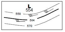
6-13 Which statement about the marine upper air
analysis chart shown below is true? a. The lowest isoheight contour is 554 dm. b. The low should move E or ENE at 40 knots. c. The low should move E or ENE at 20 knots. d. The skies over the area are entirely clear. |
c. The low should move E or ENE at 20 knots. [76]
|
|
|
|
6-14 Shading is used on 300 and 200 mb charts
to highlight areas where a. jet stream winds are strong b. pressure is lowest c. temperatures are below freezing d. there are no observations |
a. jet stream winds are strong [76]
|
|
|
|
6-15 Sea state charts display
a. contours of the highest wave heights b. wind direction arrows c. significant wave height contours d. none of the above |
c. significant wave height contours [77
|
|
|
|
6-16 Significant wave height means the average
of the measured heights of the ______ waves. a. highest b. highest 1/3 of c. swells and wind d. wind |
b. highest 1/3 of [77]
|
|
|
|
6-17 The best sources for observations of sea
state and water temperature in coastal areas are a. marine surface analysis charts b. moored data buoys or fixed installations c. sea state charts d. wind/wave charts |
b. moored data buoys or fixed installations [78]
|
|
|
|
6-18 ______ satellite images have the best contrast |
d. infrared, lighter [79] |
|
|
|
6-19 Which colors in a base reflectivity radar
image represent thunderstorms? a. blue and green b. mauve and puce c. red and yellow d. speckled rainbow |
c. red and yellow [80, 81]
|
|
|
|
6-20 A radar coded message displays
a. base reflectivity images b. speed and direction of rainstorm movement c. thunderstorm warning areas d. all of the above |
d. all of the above [80, 81]
|
|
|
|
7-1 The Auxiliary weather specialist may build
situational awareness by applying the ______ method of forecasting. a. analogy b. extrapolation c. historical d. numerical |
b. extrapolation [85]
|
|
|
|
7-2 Making a forecast by assuming that today’s
weather pattern will evolve in the same way as similar patterns from the past is known as the ______ method. a. analogy b. extrapolation c. historical d. numerical |
a. analogy [85]
|
|
|
|
7-3 You can estimate the future track of a
weather system by studying ______ . a. sea state charts b. satellite images c. radar images d. analysis charts |
d. analysis charts [88]
|
|
|
|
7-4 The best sources of wind observations are
a. analysis charts and satellite images b. base reflectivity radar images c. data buoys and analysis charts d. sea state charts and radar |
c. data buoys and analysis charts [88]
|
|
|
|
7-5 A ______ is the best source of information
about sea water temperature in your local area. a. data buoy b. sea state chart c. surface analysis chart d. water vapor satellite image |
a. data buoy [88, 89]
|
|
|
|
7-6 If a blocking ridge is situated to the east of a
low, the weather associated with the low may be expected to a. dissipate b. intensify c. move slowly or remain stationary d. retreat westward |
c. move slowly or remain stationary [89, 90]
|
|
|
|
7-7 Temporarily unsettled weather may be expected
when a ______ moves over an area. a. blocking ridge b. divergence aloft c. stationary front d. weak trough |
d. weak trough [90]
|
|
|
|
7-8 The most likely place for a low to form along
a stationary front is where ______ winds ______ . a. surface, converge b. surface, diverge c. upper air, diverge d. upper air, converge |
c. upper air, diverge [91
|
|
|
|
7-9 Thunderstorms develop most often
a. ahead of warm fronts b. behind cold fronts c. ahead of cold fronts d. near stationary fronts |
c. ahead of cold fronts [91] d.
|
|
|
|
7-10 Embedded thunderstorms
a. are hard to see until they are nearby b. occur only in squall lines c. move at 40 knots and have tops to 40,000 ft d. occur only in solid lines |
a. are hard to see until they are nearby [91]
|
|
|
|
7-11 If a severe thunderstorm warning has been
issued, one should be prepared for a. hail and/or tornadoes b. wind gusting to 30 knots or more c. very heavy rain d. all of the above |
d. all of the above [91]
|
|
|
|
7-12 The three conditions necessary for thunderstorms
to develop are a. convergence, lift, and precipitation b. instability, lift, and moisture c. lift, moisture, and stability d. lightning, low dew point, and saturation |
b. instability, lift, and moisture [92]
|
|
|
|
7-13 Moisture provides the ______ and lift provides
the ______ for thunderstorm development. a. clouds, heat b. heat, instability c. heat, trigger d. trigger, clouds |
c. heat, trigger [92]
|
|
|
|
7-14 The possible sources of lift are approaching
fronts, winds blowing over rising terrain, ______ and ______. a. converging winds, surface heating b. Coriolis effect, surface heating c. diverging winds, intense heating d. high dew point, instability |
a. converging winds, surface heating [92
|
|
|
|
7-15 As a general rule of thumb, cumulus clouds
must build to an altitude of at least ______ feet for thunderstorms to develop. a. 15,000 b. 25,000 c. 40,000 d. none of the above |
b. 25,000 [93]
|
|
|
|
7-16 The atmosphere is said to be unstable, favoring
thunderstorm development, when calculations indicate that a lifted bubble of air will always be a. saturated b. colder than the surrounding air c. warmer than the standard atmo sphere d. warmer than the surrounding air |
d. warmer than the surrounding air [93]
|
|
|
|
7-17 Long stretches of hot hazy summer weather
along the East Coast are due to a. jet streams b. mid-Atlantic lows c. prevailing westerlies d. warm air advection from the Bermuda high |
d. warm air advection from the Bermuda high [96]
|
|
|
|
7-18 In the Great Lakes region, the most destructive
thunderstorms are generally associated with a. hurricanes b. lows migrating from the west or southwest c. stationary lows d. troughs aloft |
b. lows migrating from the west or southwest [97]
|
|
|
|
7-19 The lift that triggers air mass thunderstorms
in the Gulf Coast and Florida regions is due to a. diverging surface winds b. surface heating c. terrain d. troughs aloft |
b. surface heating [97]
|
|
|
|
7-20 Moisture advection to the West Coast results
from a. circulation around the Pacific high b. migration of the Aleutian low c. orographic lift over the coastal mountains d. Santa Ana winds |
a. circulation around the Pacific high [98
|
|
|
|
7-21 In southern Alaska, winds and waves vary
widely in both direction and intensity in the a. Gulf of Alaska b. Inside Passage c. summer d. winter |
b. Inside Passage [99]
|
|
|
|
7-22 In Hawaii, the highest swells occur during
______ and approach the ______ facing coasts. a. any season, east b. hurricane season, southeast c. summer, south d. winter, north and west |
d. winter, north and west [100]
|
|
|
|
8-1 The evolution of a thunderstorm may be described
in terms of _____ , _____ , and dissipating stages. a. cumulus, cumulonimbus b. cumulus, mature c. early, late d. updraft, mature |
b. cumulus, mature [105]
|
|
|
|
8-2 A characteristic of the cumulus stage of a
thunderstorm is a. heavy rain b. thunder c. towering cumulus cloud building to cumulonimbus height d. none of the above |
c. towering cumulus cloud building to cumulonimbus height [105]
|
|
|
|
8-3 A mature thunderstorm produces
a. a gust front b. heavy rain c. thunder and lightning d. all of the above |
d. all of the above [106]
|
|
|
|
8-4 The _____ object in an area is the most likely
to be hit by a lightning strike. a. most effectively grounded b. most negatively charged c. sharpest d. tallest |
d. tallest [106]
|
|
|
|
8-5 Thunder is heard at sea level 11 seconds after
a lightning flash. The lightning was most likely at a distance of _____ miles from the observer. a. 1/2 b. 1 c. 2 d. 10 |
c. 2 [106]
|
|
|
|
8-6 The first warning sign of an impending tornado
is a a. cumulonimbus mammatus cloud b. funnel cloud c. tornado watch d. waterspout |
. cumulonimbus mammatus cloud [107]
|
|
|
|
8-7 A _____ is a hazard that may occur when a
thunderstorm is dissipating. a. downspout b. funnel cloud c. micro-burst d. mini-burst |
c. micro‐burst [107]
|
|
|
|
8-8 _____ indicate the approach of a thunderstorm
gust front. a. backing winds b. lightning strokes c. ripples on the sea surface d. veering winds |
c. ripples on the sea surface [108]
|
|
|
|
8-9 The underway precautions for lightning include
a. avoiding masts, stays, and metal objects b. lowering radio antennas c. sheltering in the boat’s cabin d. all of the above |
d. all of the above [108]
|
|
|
|
8-10 The first stage in the evolution of a hurricane
is called a tropical a. cyclone b. depression c. disturbance d. storm |
c. disturbance [109]
|
|
|
|
8-11 The primary source of lift that creates a hurricane
is _____ and is usually found on the northeast shoulder of _____ . a. convergence, an easterly wave b. convergence, a Rossby wave c. frontal, an easterly wave d. orographic, a jet stream |
a. convergence, an easterly wave [108, 109]
|
|
|
|
8-12 A tropical cyclone is classified as a hurricane
when its wind speed exceeds _____ knots. a. 32 b. 60 c. 64 d. 100 |
c. 64 [109]
|
|
|
|
8-13 The eye of a hurricane is generally _____
miles in diameter, and the storm is intens ifying when the eye _____ . a. 15 to 30, expands b. 200 or more, expands c. 15 to 30, shrinks d. 200 or more, shrinks |
c. 15 to 30, shrinks [110
|
|
|
|
8-14 The maximum wind speeds in a hurricane
are found a. in the eye b. near the inner edge of the wall cloud c. on the danger side d. both b and c |
d. both b and c [110, 111]
|
|
|
|
8-15 The worst seas in a hurricane are found
a. in the eye b. near the inner edge of the wall cloud c. on the danger side d. both b and c |
a. in the eye [110]
|
|
|
|
8-16 As you look along the track of a hurricane,
the _____ side is to the right. a. danger b. least windy c. navigable d. safe |
a. danger [111
|
|
|
|
8-17 The wind speed in a hurricane approaching
the coast is 120 mph. The storm surge will be at least _____ feet. a. 4 b. 8 c. 9 d. 13 |
c. 9 [111]
|
Table 8-2. Saffir-Simpson scale.
C P (mb) V (knots) S (ft) Damage 1 980 or more 64-82 4 – 5 Minimal 2 965 - 979 83-96 6 - 8 Moderate 3 945 – 964 97-113 9 – 12 Extensive 4 920 – 944 114-135 13 – 18 Extreme 5 less than 920 more than 135 more than 18 Catastrophic |
|
|
8-18 To escape if a hurricane is approaching the
area where you are sailing, you should keep the wind a. ahead b. astern c. to port d. to starboard |
d. to starboard [111]
|
|
|
|
8-19 You are assigned to an 8-hour patrol,
and the significant wave height is reported to be 4 feet in your area. How often should you expect the waves to make steering difficult for boats less than one hundred feet long? a. For the entire patrol b. About 10 percent of the time c. Only a few times d. Never |
b. About 10 percent of the time [112]
|
Table 8-3 gives several factors that
may be used to make a more thorough assessment of the sea state. Table 8-3. Wave height factors. For estimated height of Multiply SWH* by Most frequent waves 0.5 Average wave 0.6 Highest 10 percent of waves 1.3 Highest of 1175 waves 1.9 *SWH – significant wave height. |
|
|
8-20 On the west coast, the greatest risk to a boat
departing an inlet is when the wind is from the _____ and the current is _____ . a. east, ebbing b. west, ebbing c. west, flooding d. either a or c |
b. west, ebbing [112]
|
|
|
|
8-21 Proceeding at slow speed in a fog is advisable
because it will allow a. approaching vessels to hear you b. your lookouts to hear other vessels c. time for maneuvering to avoid a collision d. both b and c |
d. both b and c [113]
|
|
|
|
8-22 You are on patrol in the Gulf of Alaska.
The air temperature is 35 oF and the wind is 30 knots (about 35 mph). Which statement is true? a. I’m at low risk for hypothermia. b. I’m at medium risk for hypothermia. c. I’m at high risk for hypothermia. d. Yikes, I’ll get frostbitten! |
c. I’m at high risk for hypothermia. [114]
|
|
|
|
8-23 Your Alaska patrol receives a MAYDAY
call to rescue a person who fell overboard from a nearby sport fishing boat. The victim is wearing only a PFD and normal clothing. The water temperature is 34 oF. Your coxswain estimates that it will take about 20 minutes to maneuver alongside the victim. When you arrive, your main concern will most likely be to _____ . a. heave a line for the victim to grab b. haul the unconscious victim aboard c. recover the deceased victim d. prevent frostbite |
b. haul the unconscious victim aboard [114]
|
|
|
|
8-24 Which forecast implies greater risk for heat
exhaustion and/or heat stroke: air temperature of 90 oF and relative humidity of 80%, or air temperature of 80 oF and relative humidity of 90%? a. 90 oF and 80% b. 80 oF and 90% c. Doesn’t matter, they have the same risk. d. Doesn’t matter, the risks are both low. |
a. 90 oF and 80% [115]
|
|
|
|
8-25 Challenge questions
If you were instructing a boating safety class in Australia, how would you define the danger and navigable sides of a “willy- willy” (the Australian name for a hurricane)? |
The Coriolis effect makes hurricanes rotate clockwise in the southern hemisphere.
(Refer to student text Figure for an example.) The storm will track toward the west as it leaves the source region |
|
|
|
8-26 Challenge questions
The weather forecast for today’s patrol is air temperature 88 oF, dew point 84 oF. What is the heat index? What is the level of risk for heat exhaustion or heat stroke? |
First,
use the temperature –humidity graph (Appendix C, page 127 in the Student Study Guide) to find that the relative humidity is 90% for the given air temperature and dew point. Second, from Table (page 115) in the Student Study Guide, find temperature 88 in the second row. Reading across to the 90% RH column, find that the heat index is 115oF. From the shading code, this is an extreme level of risk |
|
|
|
1. The electromagnetic energy that comes from the sun consists of:a) Light.b) Ultraviolet.c) Infrared.d) All of the above.
|
d) All of the above. (4)
|
Part I—The Science of Meteorology
|
|
|
2. The amount of energy per unit area that arrives at the top of the atmosphere from the sun:a) Decreases in the winter.b) Is the same everywhere.c) Increases with increasing latitude.d) Decreases with increasing latitude.
|
d) Decreases with increasing latitude. (5) |
Part I—The Science of Meteorology |
|
|
3. The largest swings of hot and cold are:a) Day to night.b) With longitude.c) With the seasons. d) Between land and water. |
c) With the seasons. (5)
|
Part I—The Science of Meteorology |
|
|
4. With the same heat input, which heats faster?a) Water.b) Land. c) The Oceans.d) None of the above.
|
b) Land. (5) |
Part I—The Science of Meteorology |
|
|
5. The amount of solar energy that is ab-sorbed by the surface is reduced due to:a) The extra distance traveled.b) Reflection from clouds.c) The nature of the surface.d) Both b and c. |
d) Both b and c. (6) |
Part I—The Science of Meteorology |
|
|
6. The specific heat of a substance is:a) The amount of energy it can hold.b) How hot it gets before it melts.c) The heat needed to vaporize it.d) The rate of temperature increase for a given energy input. |
d) The rate of temperature increase for a given energy input. (6) |
Part I—The Science of Meteorology |
|
|
7. The air in the lower troposphere is heated mainly by:a) Absorption by air of the direct radia-tion from the sun.b) Radiation absorbed by dust in the at-mosphere.c) Cosmic rays.d) Conduction and convection from the Earth’s surface. |
d) Conduction and convection from the Earth’s surface. (8) |
Part I—The Science of Meteorology |
|
|
8. Temperature may be defined as:a) Energy produced by friction.b) Change of energy from one form to another.c) A measure of the kinetic energy of molecules.d) The pressure of the air on the ther-mometer. |
c) A measure of the kinetic energy of molecules. (6) |
Part I—The Science of Meteorology |
|
|
9. In the Celsius temperature scale, zero is defined as:a) The absence of heat.b) The temperature at which ice is the densest.c) The melting point of pure water ice.d) The freezing point of sea water. |
c) The melting point of pure water ice. (6) |
Part I—The Science of Meteorology |
|
|
10. 20° Celsius is, in Fahrenheit, to the nearest degree:a) 52°F.b) 40°F.c) 68°F.d) 75°F. |
c) 68°F. (7) |
Part I—The Science of Meteorology |
|
|
11. 59° Fahrenheit is, in Celsius, to the nearest degree:a) 27°C.b) 15°C.c) 6°C.d) 32°C. |
b) 15°C. (7) |
Part I—The Science of Meteorology |
|
|
12. The transfer of heat by the horizontal movement of air is:a) Convection.b) Conduction.c) Advection.d) Radiation
|
c) Advection. (8) |
Part I—The Science of Meteorology |
|
|
13. The transfer of heat between bodies that are not in contact is:a) Convection.b) Conduction.c) Radiation.d) Advection.
|
c) Radiation. (8 |
Part I—The Science of Meteorology |
|
|
14. In meteorology, convection means:a) Transfer of heat by contact.b) Conduction of heat by infrared radiation.c) The horizontal movement of air by winds.d) The vertical transport of heat by air.
|
d) The vertical transport of heat by air. (8) |
Part I—The Science of Meteorology |
|
|
15. Radiation is energy transfer:a) Via a medium.b) By contact.c) Resulting from friction.d) In wave form, without the neces-sity of a medium.
|
d) In wave form, without the neces-sity of a medium. (8) |
Part I—The Science of Meteorology |
|
|
16. Large land masses, as opposed to the oceans:a) Maintain a steadier temperature.b) Are always warmer.c) Change temperature more be-tween night and day.d) Are cooler during the day.
|
c) Change temperature more be-tween night and day. (5) |
Part I—The Science of Meteorology |
|
|
17. The cause of most weather phenomena is:a) The layers in the atmosphere.b) The rotation of the Earth.c) The revolution around the Sun.d) Uneven heating of the Earth’s surface.
|
d) Uneven heating of the Earth’s surface. (5) |
Part I—The Science of Meteorology |
|
|
18. For the station model shown below, the temperature reported is:a) 53 °C.b) 5.3 °F.c) 53 °F. d) 5.3 °C.5319. The Coriolis
|
b) Increases with increasing wind speed. (9, 10) |
Part I—The Science of Meteorology |
|
|
19. The Coriolis effect:a) Decreases with increasing latitude.b) Increases with increasing wind speed.c) Always turns winds to the right.d) Operates over long and short dis-tances.
|
b) Increases with increasing wind speed. (9, 10) |
Part I—The Science of Meteorology |
|
|
20. The winds near the equator are called:a) Trade winds.b) Doldrums.c) Prevailing easterlies.d) The ITCZ.
|
a) Trade winds. (10) |
Part I—The Science of Meteorology |
|
|
21. On a rotating, smooth Earth, the low pressure bands parallel to the equator are the __________and the _________.a) Doldrums, Horse Latitudes.b) Horse Latitudes, Westerlies.c) Doldrums, Sub-polar Low.d) Horse Latitudes, Polar Low
|
c) Doldrums, Sub-polar Low. (10 |
Part I—The Science of Meteorology |
|
|
22. The Doldrums is a belt of relatively:a) Low temperature.b) Low humidity.c) Low pressure. d) High latitude
|
c) Low pressure. (10) |
Part I—The Science of Meteorology |
|
|
23. Which of the following is not one of the primary wind belts?a) The polar westerlies.b) The northeast trades.c) The southeast trades.d) The prevailing westerlies.
|
a) The polar westerlies. (10) |
Part I—The Science of Meteorology |
|
|
24. The Inter-tropical Convergence Zone (ITCZ) is located:a) On the equator.b) 15° north of the equator.c) 15° south of the equator.d) Either side of the equator, depend-ing on the season.
|
d) Either side of the equator, depend-ing on the season. (10) |
Part I—The Science of Meteorology |
|
|
25. The trade winds:a) Vary widely in speed.b) Reverse direction with the seasons.c) Blow only in the northern hemi-sphere.d) Blow from the Horse Latitudes to the Doldrums.
|
d) Blow from the Horse Latitudes to the Doldrums. (10) |
Part I—The Science of Meteorology |
|
|
27. Heat is transported northward and south-ward from the equator by:a) Winds.b) Ocean Currents.c) Neither of the above.d) Both a) and b).
|
d) Both a) and b). (5) |
Part I—The Science of Meteorology |
|
|
28. Insolation is:a) The sun’s apparent motion from east to west.b) The reduction in temperature due to clouds.c) The amount of energy reaching the Earth’s surface.d) The inclination of the Earth’s axis.
|
c) The amount of energy reaching the Earth’s surface. (6) |
Part I—The Science of Meteorology |
|
|
29. An example of a synoptic scale phenom-enon is:a) A tornado.b) An air mass. c) The prevailing westerlies.d) None of the above.
|
b) An air mass. (58) |
Part I—The Science of Meteorology |
|
|
30. An example of a mesoscale phenome-non is:a) A thunderstorm.b) A frontal system.c) The semi-permanent pressure cen-ters.d) None of the above.
|
a) A thunderstorm. (58) |
Part I—The Science of Meteorology |
|
|
31. The trade winds are an example of:a) A global scale phenomenon.b) A mesoscale phenomenon.c) A synoptic scale phenomenon.d) A microscale phenomenon
|
a) A global scale phenomenon. (11) |
Part I—The Science of Meteorology |
|
|
1. A north wind is one that is:a) Blowing toward the north.b) Shifting toward the north.c) Coming from the north.d) Blowing from the North Pole.
|
c) Coming from the north. (18)
|
Chapter 2 Pressure and Winds
|
|
|
2. Wind speeds on charts are given in:a) Miles per hour.b) Kilometers per hour.c) Feet per second.d) Knots.
|
d) Knots. (21) |
Chapter 2 Pressure and Winds |
|
|
3. Standard sea-level pressure is:a) 1013.26 in Hg.b) 29.92 psi.c) 760 kPa.d) 14.7 psi. 4. If the barometric pressure
|
d) 14.7 psi. (15) |
Chapter 2 Pressure and Winds |
|
|
3. Standard sea-level pressure is:a) 1013.26 in Hg.b) 29.92 psi.c) 760 kPa.d) 14.7 psi. 4. If the barometric pressure
|
d) 14.7 psi. (15) |
Chapter 2 Pressure and Winds |
|
|
5. Station barometric pressures are “re-duced to sea level”:a) To correct instrument error.b) To correct for the temperature.c) So data taken at different altitudes can be compared.
|
c) So data taken at different altitudes can be compared. (16) |
Chapter 2 Pressure and Winds |
|
|
6. Aneroid barometers are more useful on boats because they:a) Contain less mercury.b) Don’t need calibration.c) Are more accurate.d) Can be mounted in any position.
|
d) Can be mounted in any position. (15) |
Chapter 2 Pressure and Winds |
|
|
7. Pressure gradient is defined as:a) Pressure difference due to wind.b) Pressure difference due to changing temperature.c) Pressure change per unit distance. |
c) Pressure change per unit distance. (15) |
Chapter 2 Pressure and Winds |
|
|
8. The primary force generating wind is:a) Coriolis force.b) Pressure gradient force. c) Temperature gradient.d) Surface heating.
|
b) Pressure gradient force. (15) |
Chapter 2 Pressure and Winds |
|
|
9. The effect of friction on the wind is:a) To slow the wind. b) To increase the Coriolis effect.c) Independent of altitude.d) To cause the wind to follow con-tours. |
a) To slow the wind. (18) |
Chapter 2 Pressure and Winds |
|
|
10. Cyclonic wind flow is:a) Clockwise in the northern hemi-sphere.b) Counter-clockwise in the southern hemisphere.c) Clockwise in the southern hemi-sphere. d) Counter-clockwise in both hemi-spheres.
|
c) Clockwise in the southern hemi-sphere. (18) |
Chapter 2 Pressure and Winds |
|
|
11. The jet stream is:a) A warm ocean current.b) An equatorial wind current.c) A high altitude wind current. d) A low altitude wind current
|
c) A high altitude wind current. (21) |
Chapter 2 Pressure and Winds |
|
|
12. If an observer is facing the wind in the northern hemisphere, the low pressure center is approximately:a) Ahead of him.b) To her right.c) To her left.d) Behind him. |
b) To her right. (19) |
Chapter 2 Pressure and Winds |
|
|
13. The Buys-Ballot law tells us:a) The wind direction in the northern hemisphere.b) The direction the wind is shifting.c) The location of the low pressure.d) The way the pressure is changing.
|
c) The location of the low pressure. (19) |
Chapter 2 Pressure and Winds |
|
|
14. A wind gradually changing in a clock-wise fashion is:a) Backing.b) Veering.c) Increasing in speed.d) Due to the sea breeze effect.
|
b) Veering. (18)
|
Chapter 2 Pressure and Winds |
|
|
15. On the station model, a plotted pressure of 853 is:a) 1085.3 mb.b) 985.3 mb. c) 853 mb.d) 85.3 mb.
|
b) 985.3 mb. (20) |
Chapter 2 Pressure and Winds |
|
|
16. On the station model, a plotted pressure tendency of -26 is:a) A rise of 2.6 mb over 3 hours.b) A fall of 2.6 mb over 1 hour.c) A fall of 26 mb over 24 hours.d) A fall of 2.6 mb over 3 hours.
|
d) A fall of 2.6 mb over 3 hours. (20) |
Chapter 2 Pressure and Winds |
|
|
17. Isobars are lines of constant:a) Temperature.b) Wind direction.c) Pressure. d) Wind speed. |
c) Pressure. (17) |
Chapter 2 Pressure and Winds |
|
|
18. The station model below shows:a) A NE wind of 15 knots.b) A SW wind of 1.5 knots.c) A NE wind of 1.5 knots.d) A SW wind of 15 knots.
|
d) A SW wind of 15 knots. (20) |
Chapter 2 Pressure and Winds |
|
|
19. Rossby waves are:a) Waves on a lake.b) Pressure waves at the surface.c) Large upper-level waves that propagate around the globe. d) The meandering of the ITCZ.
|
c) Large upper-level waves that propagate around the globe. (21) |
Chapter 2 Pressure and Winds |
|
|
20. The solid lines on a 500 mb chart are:a) Isotherms.b) Isoheights. c) Isobars.d) Isopressures.
|
b) Isoheights. (21) |
Chapter 2 Pressure and Winds |
|
|
21. The pattern at 500 mb that causes sur-face low pressure areas to strengthen is:a) Negative temperature advection.b) Positive temperature convection.c) Backing winds.d) Diverging isoheights.
|
d) Diverging isoheights (22). |
Chapter 2 Pressure and Winds |
|
|
22. The jet stream shows up best on the:a) 500 mb chart.b) The surface chart.c) The 300 mb chart. d) The 100 mb chart.
|
c) The 300 mb chart. (21) |
Chapter 2 Pressure and Winds |
|
|
23. Lines of constant temperature are:a) Found on upper-level charts.b) Plotted as dashed lines.c) Isotherms.d) All of the above.
|
d) All of the above (21). |
Chapter 2 Pressure and Winds |
|
|
24. On the 500 mb chart, ridges are:a) Convex to the north.b) Concave to the north.c) Areas of lower pressure.d) Convex to the south.
|
a) Convex to the north. (20) |
Chapter 2 Pressure and Winds |
|
|
25. Surface pressure is caused by:a) The weight of the air in the tropo-sphere.b) The weight of the air above. c) The winds striking buildings.d) The weight of the air in the strato-sphere.
|
b) The weight of the air above. (15) |
Chapter 2 Pressure and Winds |
|
|
26. Isobars on a standard surface chart are drawn every:a) 5 mb.b) 4 mb.c) 3 mb.d) 10 mb.
|
b) 4 mb. (17) |
Chapter 2 Pressure and Winds |
|
|
27. Higher pressure gradients cause:a) Rising temperatures.b) Falling temperatures.c) Stronger winds. (15)d) Lighter winds.
|
c) Stronger winds. (15) |
Chapter 2 Pressure and Winds |
|
|
28. The polar jet stream:a) Originates over the North Pole.b) Is confined to the polar high.c) Plays a role in steering weather systems.d) Flows from east to west.
|
c) Plays a role in steering weather systems. (21) |
Chapter 2 Pressure and Winds |
|
|
29. The standard instrument for measuring wind direction and speed is the:a) Aneroid barometer.b) Psychrometer.c) Anemometer.d) Thermocouple thermometer
|
c) Anemometer. (19)d) |
Chapter 2 Pressure and Winds |
|
|
30. Half of the total mass in the atmosphere is in the lowest:a) 8,000 ft.b) 12,000 ft.c) 18,000 ft. (d) 25,000 ft.
|
c) 18,000 ft. (20) |
Chapter 2 Pressure and Winds |
|
|
1. In the lower atmosphere, the temperature generally:a) Increases with altitude.b) Stays the same.c) Decreases with altitude. d) Varies randomly
|
c) Decreases with altitude. (26) |
Chapter 3 Moisture, Latent Heat, Fog and Stability
|
|
|
2. The tropopause is important in weather de-velopment since it:a) Contains most of the moisture.b) Disappears during turbulent weather.c) Caps the development of convective activity.d) Varies Randomly
|
c) Caps the development of convective activity. (26) |
Chapter 3 Moisture, Latent Heat, Fog and Stability |
|
|
3. One difference between the troposphere and the stratosphere is:a) Carbon dioxide content.b) Argon content.c) Temperature distribution.d) Thickness.
|
c) Temperature distribution. (26) |
Chapter 3 Moisture, Latent Heat, Fog and Stability |
|
|
4. The most abundant gases in the atmosphere are:a) Nitrogen and Hydrogen.b) Oxygen and Nitrogen. c) Nitrogen and Argon.d) Carbon Dioxide and Methane
|
b) Oxygen and Nitrogen. (26) |
Chapter 3 Moisture, Latent Heat, Fog and Stability |
|
|
5. The average environmental lapse rate in the lower atmosphere is:a) -3.2° C per 1,000 ft.b) +3.5°F. per 1,000 ft.c) -2.2°C. per 1,000 ft.d) -3.5°F. per 1,000 ft.
|
d) -3.5°F. per 1,000 ft. (26) |
Chapter 3 Moisture, Latent Heat, Fog and Stability |
|
|
6. A temperature increase with altitude in the lower atmosphere is called:a) The tropopause.b) An inversion.c) A thermal.d) Convection.
|
b) An inversion. (27) |
Chapter 3 Moisture, Latent Heat, Fog and Stability |
|
|
7. A dry, warm wind descending the east side of the Rocky Mountains is a:a) Chinookb) Valley breeze.c) Land breeze.d) Wind shear
|
a) Chinook. (31, 32) |
Chapter 3 Moisture, Latent Heat, Fog and Stability |
|
|
8. Water vapor is added to the air by:a) Condensation.b) Evaporation.c) Vapor pressure.d) Deposition.
|
b) Evaporation. (29) |
Chapter 3 Moisture, Latent Heat, Fog and Stability |
|
|
9. When water vapor condenses, heat is:a) Added.b) Released. (c) Not changed.d) Absorbed.
|
b) Released. (27, 28) |
Chapter 3 Moisture, Latent Heat, Fog and Stability |
|
|
10. The transition from ice to vapor without go-ing through the liquid phase is called:a) Effervescence.b) Sublimation. c) Evaporation.d) Deposition
|
b) Sublimation. (28) |
Chapter 3 Moisture, Latent Heat, Fog and Stability |
|
|
11. Latent heat:a) Can be measured with a thermometer.b) Is released when water freezes.c) Is released when water vaporizes.d) Can be felt.
|
b) Is released when water freezes. (29) |
Chapter 3 Moisture, Latent Heat, Fog and Stability |
|
|
12. Saturation can be accomplished by:a) Raising absolute humidity while holding the temperature constant.b) Lowering the temperature while the ab-solute humidity remains constant.c) Either a) or b).d) None of the above.
|
c) Either a) or b). (29) |
Chapter 3 Moisture, Latent Heat, Fog and Stability |
|
|
13. The temperature at which water vapor be-gins to condense is called the:a) Condensation level.b) Saturation temperature.c) Dew point. d) Melting point.
|
c) Dew point. (29) |
Chapter 3 Moisture, Latent Heat, Fog and Stability |
|
|
14. If the water vapor content of an air parcel in-creases at constant temperature, the relative humidity ____ and the dew point _____.a) Decreases, Increases.b) Increases, Decreases.c) Increases, Increases. d) Decreases, Decreases
|
c) Increases, Increases. (29) |
Chapter 3 Moisture, Latent Heat, Fog and Stability |
|
|
15. When air is saturated with water vapor:a) The dew point depression is zero.b) The relative humidity is 100%.c) The air can hold no more vapor.d) All of the above.
|
d) All of the above. (28, 29) |
Chapter 3 Moisture, Latent Heat, Fog and Stability |
|
|
16. Regarding the latent heat of fusion and the latent heat of vaporization of water:a) They are the same.b) Latent heat of fusion is higher.c) Latent heat of vaporization is higher.d) They are determined by the specific heat of water.
|
c) Latent heat of vaporization is higher. (27) |
Chapter 3 Moisture, Latent Heat, Fog and Stability |
|
|
17. The term adiabatic means:a) No heat is added or subtracted.b) The pressure is constant.c) The temperature is constant.d) The absolute humidity is constant
|
a) No heat is added or subtracted. (27) |
Chapter 3 Moisture, Latent Heat, Fog and Stability |
|
|
18. The dry adiabatic lapse rate, compared to the wet adiabatic lapse rate is:a) Smaller.b) More negative. (27)c) Less negative.d) Positive.
|
b) More negative. (27) |
Chapter 3 Moisture, Latent Heat, Fog and Stability |
|
|
19. The physical property or properties of water important to the weather is/are:a) It can transport energy from one location to another.b) It takes a lot of energy to vaporize it.c) It absorbs a lot of infrared energy.d) All of the above
|
d) All of the above |
Chapter 3 Moisture, Latent Heat, Fog and Stability |
|
|
20. The term describing the tendency of dis-placed air to return to its former level is:a) Absolute instability.b) Elasticity.c) Absolute stability.d) Conditional stability.
|
c) Absolute stability. (31) |
Chapter 3 Moisture, Latent Heat, Fog and Stability |
|
|
21. The term describing the tendency of air to rise on its own is:a) Absolute instability.b) Elasticity.c) Absolute stability.d) Conditional stability.
|
a) Absolute instability. (30) |
Chapter 3 Moisture, Latent Heat, Fog and Stability |
|
|
22. The term describing the tendency of air to rise only after it has been initially raised to some higher altitude is:a) Absolute instability.b) Elasticity.c) Absolute stability.d) Conditional stability.
|
d) Conditional stability. (31) |
Chapter 3 Moisture, Latent Heat, Fog and Stability |
|
|
23. Fog that forms by adding moisture is:a) Radiation fog.b) Advection fogc) Precipitation fog. d) None of the above.
|
c) Precipitation fog. (30) |
Chapter 3 Moisture, Latent Heat, Fog and Stability |
|
|
24. Fog that forms under clear skies at night is:a) Radiation fog. b) Advection fog.c) Precipitation fog.d) All of the above.
|
a) Radiation fog. (30) |
Chapter 3 Moisture, Latent Heat, Fog and Stability |
|
|
1. In highs, the:a) Air spirals into the center.b) Air rises.c) Air spirals out of the center.d) Weather is usually foul.
|
c) Air spirals out of the center. (38) |
Chapter 4 Air Masses, Fronts, and Cyclones
|
|
|
2. In lows, the:a) Air spirals into the center. (38)b) Air sinks.c) Air spirals out of the center.d) Weather is usually fair.
|
a) Air spirals into the center. (38) |
Chapter 4 Air Masses, Fronts, and Cyclones |
|
|
3. Normally, air masses travel across the U.S.:a) From east to west.b) Faster in the winter than the sum-mer.c) Faster in the summer than the winter.d) The same speed all year.
|
b) Faster in the winter than the sum-mer. (36)
|
Chapter 4 Air Masses, Fronts, and Cyclones |
|
|
4. Precipitation ahead of a warm front is usually:a) Short in duration and showery.b) Non-existent.c) Impossible to predict.d) Long in duration and steady.
|
d) Long in duration and steady. (40) |
Chapter 4 Air Masses, Fronts, and Cyclones |
|
|
5. Precipitation ahead of a cold front is usually:a) Short in duration and showery. b) Non-existent.c) Impossible to predict.d) Long in duration and steady.
|
a) Short in duration and showery. (39) |
Chapter 4 Air Masses, Fronts, and Cyclones |
|
|
6. When a cold front passes, the wind:a) Veers sharply.b) Backs sharply.c) Reverses direction.d) Stops blowing. |
b) Backs sharply. (40) |
Chapter 4 Air Masses, Fronts, and Cyclones |
|
|
7. As a cold front passes, the winds are:a) Calm.b) Strong and gusty. c) From the south.d) From the east. |
b) Strong and gusty. (37) |
Chapter 4 Air Masses, Fronts, and Cyclones |
|
|
8. Conditions after a cold front are usually:a) Good visibility with low stratus clouds.b) Poor visibility with low stratus clouds.c) Good visibility with cumulus clouds. d) Poor visibility with cumulus clouds. |
) Good visibility with cumulus clouds. (40) |
Chapter 4 Air Masses, Fronts, and Cyclones |
|
|
9. In the occluded portion of a cyclone, the warm air:a) Has moved away.b) Is trapped at the surface.c) Is held aloft.d) Pushes under the cool air. |
c) Is held aloft. (41) |
Chapter 4 Air Masses, Fronts, and Cyclones |
|
|
10. An occluded front is formed when:a) A fast warm front overrides a cold front.b) A fast cold front overtakes a warm front.c) Moist air displaces dry air.d) A cold front stalls. |
b) A fast cold front overtakes a warm front. (41) |
Chapter 4 Air Masses, Fronts, and Cyclones |
|
|
11. North of a low:a) There are no fronts.b) The winds back as the low passes.c) There is no warm sector.d) All of the above. |
d) All of the above. (42) |
Chapter 4 Air Masses, Fronts, and Cyclones |
|
|
12. The polar front forms storm systems be-cause:a) It encourages the formation of anti-cyclones.b) The polar westerlies and prevailing easterlies oppose each other.c) The prevailing westerlies and po-lar easterlies oppose each other. d) None of the above. |
c) The prevailing westerlies and po-lar easterlies oppose each other. (43) |
Chapter 4 Air Masses, Fronts, and Cyclones |
|
|
13. The jet stream is:a) An ocean current.b) A low-level wind.c) A high altitude wind. d) Over the equator. |
c) A high altitude wind. (43) |
Chapter 4 Air Masses, Fronts, and Cyclones |
|
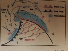
14. Clouds in area 1 are typically:a) Cumuliform.b) Stratiform.c) Cirriform.d) Absent. |
b) Stratiform. (40, 42) |
Chapter 4 Air Masses, Fronts, and Cyclones |
|

15. Clouds in area 5 are typically:a) Cumuliform.b) Stratiform.c) Cirriform.d) Absent |
a) Cumuliform. (40, 42) |
Chapter 4 Air Masses, Fronts, and Cyclones |
|

16. Clouds in area 3 are typically:a) Cumuliform. b) Stratiform.c) Cirriform.d) Nimbostratus. |
a) Cumuliform. (40, 42) |
Chapter 4 Air Masses, Fronts, and Cyclones |
|

17. The front next to 7 is a:a) Cold front.b) Warm front.c) Stationary front.d) Occluded front. |
a) Cold front. (39) |
Chapter 4 Air Masses, Fronts, and Cyclones |
|

18. The front next to 6 is a:a) Cold front.b) Warm front. c) Stationary front.d) Occluded front |
b) Warm front. (40) |
Chapter 4 Air Masses, Fronts, and Cyclones |
|

19. The wind has veered to the NW, the thunderstorms are over and the barome-ter is rising rapidly. Where are you?a) 1.b) 7.c) 5. d) 3. |
c) 5. (38, 39) |
Chapter 4 Air Masses, Fronts, and Cyclones |
|

20. It is now colder, the wind is NW, the sky is clear or partly cloudy. Where are you?a) 1.b) 7.c) 5.d) 3. |
d) 3. |
Chapter 4 Air Masses, Fronts, and Cyclones |
|

21. The winds have been backing most of the day. Where are you?a) 6.b) 7.c) 4. d) 3 |
c) 4. (42) |
Chapter 4 Air Masses, Fronts, and Cyclones |
|

22. A mid-latitude cyclone like this one will typically move in the direction from:a) 5 to 1. b) 4 to 1.c) 6 to 1.d) 1 to 6.
|
a) 5 to 1. (41) |
Chapter 4 Air Masses, Fronts, and Cyclones |
|
|
23. Divergence aloft can be caused by:a) The wind speeding up with dis-tance.b) The wind slowing down with dis-tance.c) The wind veering.d) The temperature falling.
|
a) The wind speeding up with dis-tance. (38) |
Chapter 4 Air Masses, Fronts, and Cyclones |
|
|
24. Divergence aloft encourages cyclone formation because it:a) Supports surface divergence.b) Causes air to sink.c) Supports surface convergence. d) Prevents surface convergence
|
c) Supports surface convergence. (38) |
Chapter 4 Air Masses, Fronts, and Cyclones |
|
|
25. The paths of cyclones across the U. S. are determined by:a) The cyclonic wind flow.b) High pressure to the west and low pressure to the east.c) Steering winds at the surface.d) Steering winds at and above 18,000 feet.
|
d) Steering winds at and above 18,000 feet. (41) |
Chapter 4 Air Masses, Fronts, and Cyclones |
|
|
26. Cyclones can form:a) Over the gulf.b) Over the Pacific Ocean.c) Over the Great Plains.d) All of the above.
|
d) All of the above. (43) |
Chapter 4 Air Masses, Fronts, and Cyclones |
|
|
27. The symbol for a cold front is a line with:a) Semi-circles.b) Triangles. c) Triangles and semi-circles on differ-ent sides.d) Triangles and semi-circles on the same side
|
b) Triangles. (39) |
Chapter 4 Air Masses, Fronts, and Cyclones |
|
|
28. The symbol for an occluded front is a line with:a) Semi-circles.b) Triangles.c) Triangles and semi-circles on differ-ent sides.d) Triangles and semi-circles on the same side.
|
d) Triangles and semi-circles on the same side. (39) |
Chapter 4 Air Masses, Fronts, and Cyclones |
|
|
29. The symbol for a stationary front is a line with:a) Semi-circles.b) Triangles.c) Triangles and semi-circles on dif-ferent sides.d) Triangles and semi-circles on the same side.
|
c) Triangles and semi-circles on dif-ferent sides. (39) |
Chapter 4 Air Masses, Fronts, and Cyclones |
|
|
30. The symbol for a warm front is a line with:a) Semi-circles.b) Triangles.c) Triangles and semi-circles on differ-ent sides.d) Triangles and semi-circles on the same side.
|
a) Semi-circles. (39) |
Chapter 4 Air Masses, Fronts, and Cyclones |
|
|
31. A cP air mass moving through the mid-west will:a) Cool from below.b) Pick up additional moisture.c) Warm from below.d) Both b and c.
|
d) Both b and c. (37) |
Chapter 4 Air Masses, Fronts, and Cyclones |
|
|
32. An mT air mass moving up the east coast will:a) Cool from below.b) Pick up additional moisture.c) Both a and b. d) Neither a nor b. |
c) Both a and b. (37) |
Chapter 4 Air Masses, Fronts, and Cyclones |
|
|
33. A cold-core low does what as the alti-tude increases?a) Fills.b) Deepens.c) Expands.d) None of the above. |
b) Deepens. (44) |
Chapter 4 Air Masses, Fronts, and Cyclones |
|
|
34. A warm-core low does what as the alti-tude increases?a) Fills.b) Deepens.c) Expands.d) None of the above. |
a) Fills. (44) |
Chapter 4 Air Masses, Fronts, and Cyclones |
|
|
1. “Nimbo” added to a cloud name means:a) High clouds.b) Low clouds.c) Precipitation. d) Thick, dark clouds. |
c) Precipitation. (48)
|
Chapter 5 Clouds, Precipitation, and Optical Phenomena |
|
|
2. Clouds with a horizontal, layered ap-pearance would be:a) Stratiform.b) Nimbostratus.c) Cirriform.d) Cumuliform.
|
a) Stratiform. (48) |
Chapter 5 Clouds, Precipitation, and Optical Phenomena |
|
|
3. Clouds with a wispy appearance are:a) Stratiform.b) Nimbostratus.c) Cirriform.
|
c) Cirriform. (48) |
Chapter 5 Clouds, Precipitation, and Optical Phenomena |
|
|
4. Clouds with a lumpy appearance are:a) Stratiform.b) Nimbostratus.c) Cirriform.d) Cumuliform.
|
d) Cumuliform. (48) |
Chapter 5 Clouds, Precipitation, and Optical Phenomena |
|
|
5. Which type of cloud produces precipita-tion?a) Altocumulus.b) Stratocumulus.c) Nimbostratus. d) Cirrostratus.
|
c) Nimbostratus. (49) |
Chapter 5 Clouds, Precipitation, and Optical Phenomena |
|
|
6. Middle clouds range in altitude:a) Below 6,500 feet.b) Between 6,500 feet and 20,000 feet. c) Above 20,000 feet.d) Below 10,000 feet.
|
a) Below 6,500 feet.b) Between 6,500 feet and 20,000 feet. (48) |
Chapter 5 Clouds, Precipitation, and Optical Phenomena |
|
|
7. Low cloud bases are found:a) Below 6,500 feet. b) Between 6,500 feet and 20,000 feet.c) Above 20,000 feet.d) Below 10,000 feet.
|
a) Below 6,500 feet. (48) |
Chapter 5 Clouds, Precipitation, and Optical Phenomena |
|
|
8. Clouds that develop vertically are:a) Stratocumulus.b) Nimbostratus.c) Altocumulus.d) Cumulus.
|
d) Cumulus. (51) |
Chapter 5 Clouds, Precipitation, and Optical Phenomena |
|
|
9. What type of cloud would you associate with the phrase “mares’ tails”?a) Cirrus. b) Cirrostratus.c) Altocumulus.d) Stratus.
|
a) Cirrus. (50) |
Chapter 5 Clouds, Precipitation, and Optical Phenomena |
|
|
10. What type of cloud would you associate with the phrase “mackerel sky”?a) Altostratus.b) Altocumulus.c) Cirrocumulus. d) Cumulonimbus
|
c) Cirrocumulus. (50) |
Chapter 5 Clouds, Precipitation, and Optical Phenomena |
|
|
11. Cirrus clouds consist of:a) Water droplets.b) Ice particles.c) Super-cooled water vapor.d) Fine mist.
|
b) Ice particles. (51) |
Chapter 5 Clouds, Precipitation, and Optical Phenomena |
|
|
12. Nimbostratus clouds produce:a) Halos.b) Beautiful sunsets.c) Precipitation.d) Dust storms.
|
c) Precipitation. (49) |
Chapter 5 Clouds, Precipitation, and Optical Phenomena |
|
|
13. Halos around the sun and moon are caused by:a) Altostratus.b) Cirrostratus. c) Nimbostratus.d) Nimbocumulus.
|
b) Cirrostratus. (51) |
Chapter 5 Clouds, Precipitation, and Optical Phenomena |
|
|
14. A heavy, dark cloud from which a steady rain is falling is:a) Altostratus.b) Nimbostratus.c) Cumulonimbus.d) Cumulus.
|
b) Nimbostratus. (49) |
Chapter 5 Clouds, Precipitation, and Optical Phenomena |
|
|
15. For precipitation to fall from a cloud:a) The air must rise adiabatically.b) The cloud particles must coalesce.c) The winds must be more than 20 knots.d) The air must sink adiabatically.
|
b) The cloud particles must coalesce. (53) |
Chapter 5 Clouds, Precipitation, and Optical Phenomena |
|
|
16. The factor that best determines what type of precipitation occurs is:a) The vertical temperature profile. b) The vertical wind profile.c) The upper level winds
|
a) The vertical temperature profile. (54) |
Chapter 5 Clouds, Precipitation, and Optical Phenomena |
|
|
17. Hailstones are always:a) Larger than 2 inches.b) Smaller than ¼ inch.c) Produced in thunderstorms.d) Rime.18. The wintertime
|
c) Produced in thunderstorms. (54) |
Chapter 5 Clouds, Precipitation, and Optical Phenomena |
|
|
19. Rime ice is a deposit that forms when ____ comes into contact with a surface.a) Sleet.b) Super-cooled water droplets. c) Snow.d) Soft hail.
|
b) Super-cooled water droplets. (55) |
Chapter 5 Clouds, Precipitation, and Optical Phenomena |
|
|
20. Clouds that form “caps” on the top of mountains are called:a) Mountain clouds.b) Lenticular clouds.c) Chinook clouds.d) Cirrus clouds.
|
b) Lenticular clouds. (52) |
Chapter 5 Clouds, Precipitation, and Optical Phenomena |
|
|
21. The fact that the sky is blue results from:a) The preferential scattering of blue light by the atmosphere.b) The refraction of red light from the sun’s rays.c) An optical illusion.d) The presence of thin cirrus clouds.
|
a) The preferential scattering of blue light by the atmosphere. (56) |
Chapter 5 Clouds, Precipitation, and Optical Phenomena |
|
|
22. Clouds to the west at sunset are red be-cause:a) The air to the west scatters more blue light.b) The light has farther to travel through the atmosphere.c) Red light is scattered less than the other colors.d) All of the above.
|
d) All of the above. (56, 57) |
Chapter 5 Clouds, Precipitation, and Optical Phenomena |
|
|
23. Halos are caused by:a) Thin ice clouds.b) Ice crystals in the air.c) The presence of cirrostratus.d) All of the above.
|
d) All of the above. (51, 57) |
Chapter 5 Clouds, Precipitation, and Optical Phenomena |
|
|
24. Rainbows require:a) Rain drops and low humidity.b) Rain drops and direct sunlight. c) Ice crystals in the direction opposite the sun.d) Cloud droplets behind you.
|
b) Rain drops and direct sunlight. (57) |
Chapter 5 Clouds, Precipitation, and Optical Phenomena |
|
|
25. To see a primary rainbow, you must:a) Have your back to the sun. b) Face the sun.c) Have your back to the rain.d) Have clear skies.
|
a) Have your back to the sun. (57) |
Chapter 5 Clouds, Precipitation, and Optical Phenomena |
|
|
26. When a secondary rainbow is formed, it is fainter because:a) It has two reflections in the rain drop.b) It is farther away.c) The colors are reversed.d) None of the above.
|
a) It has two reflections in the rain drop. (57)
|
Chapter 5 Clouds, Precipitation, and Optical Phenomena |
|
|
1. The life cycle of a thunderstorm has stages:a) Synoptic, meso, and micro.b) Cumulus, mature, and dissipating. c) Cumulus and cumulonimbus.d) Updraft and down draft
|
b) Cumulus, mature, and dissipating. (61)
|
Chapter 6 Severe Weather |
|
|
2. The first stage of a thunderstorm cell has:a) Downdrafts only.b) Updrafts only. c) Updrafts and downdrafts.d) None of the above
|
b) Updrafts only. (61, 62) |
Chapter 6 Severe Weather |
|
|
3. The mature stage of a thunderstorm cell has:a) Downdrafts only.b) Updrafts only.c) Updrafts and downdrafts. d) None of the above.
|
c) Updrafts and downdrafts. (61, 62) |
Chapter 6 Severe Weather |
|
|
4. The dissipation stage of a thunderstorm has:a) Cold updrafts.b) Cold downdrafts. c) Warm updrafts.d) Warm downdrafts.
|
b) Cold downdrafts. (62) |
Chapter 6 Severe Weather |
|
|
5. Squall lines are long lasting because:a) Downbursts from existing cells cause others to develop. b) Cells multiply by splitting.c) Cells don’t have a dissipation stage.d) None of the above.
|
a) Downbursts from existing cells cause others to develop. (62) |
Chapter 6 Severe Weather |
|
|
6. The distinguishing characteristic of a supercell is:a) It has no downdrafts.b) It contains a large, rotating meso-cyclone. c) It never produces tornados.d) There are no other thunderstorms in the area.
|
b) It contains a large, rotating meso-cyclone. (63) |
Chapter 6 Severe Weather |
|
|
7. The condition(s) that favor the develop-ment of thunderstorms are:a) A supply of warm, moist air.b) An unstable lapse rate.c) A lifting mechanism.d) All of the above.
|
d) All of the above. (61, 62) |
Chapter 6 Severe Weather |
|
|
8. Individual thunderstorms on a hot after-noon are most likely:a) Orographic.b) Air mass. c) Frontal.d) Squall line.
|
b) Air mass. (62) |
Chapter 6 Severe Weather |
|
|
9. As a thunderstorm approaches, the wind is likely to be:a) First out of the cloud, then toward it.b) First toward the cloud, then out of it. c) First cold, then warm.d) Light and variable.
|
b) First toward the cloud, then out of it. (61)
|
Chapter 6 Severe Weather |
|
|
10. Downbursts and microbursts are associ-ated with:a) Nimbostratus clouds.b) Cumulonimbus clouds. c) Towering cumulus clouds.d) Down-slope winds
|
b) Cumulonimbus clouds. (64) |
Chapter 6 Severe Weather |
|
|
11. Microbursts are more dangerous than or-dinary downbursts because of their:a) Tendency to form out of a clear sky.b) Small size, high winds, and sudden onset. c) Relatively long life and large area.d) Association with developing thun-derstorms
|
b) Small size, high winds, and sudden onset. (64) |
Chapter 6 Severe Weather |
|
|
12. The estimated distance to a thunder-storm if you hear the thunder 20 seconds after you see the lightning is:a) 4 kilometers.b) 2 statute miles.c) 4 statute miles. d) 2 nautical miles.
|
c) 4 statute miles. (64) |
Chapter 6 Severe Weather |
|
|
13. Tornados are:a) Rotation vortices that do not touch the ground.b) Micro-hurricanes.c) Rotation vortices that touch the ground. d) Severe thunderstorms.
|
c) Rotation vortices that touch the ground. (65) |
Chapter 6 Severe Weather |
|
|
14. Tornados have been observed in:a) Only the gulf coast and east coast.b) All 50 states. c) Only during the winter.d) Only during the summer
|
b) All 50 states. (65) |
Chapter 6 Severe Weather |
|
|
15. Tornados are known for their:a) Enormous destructive paths.b) High winds. c) Ease of forecasting.d) Long lifetimes.
|
b) High winds. (65) |
Chapter 6 Severe Weather |
|
|
16. The most intense tornados are associated with:a) Hail.b) Supercells.c) Squall lines.d) Mesoscale convective complexes
|
b) Supercells. (63)
|
Chapter 6 Severe Weather |
|
|
17. The Enhanced Fujita scale for tornados is based on:a) The measured wind speed.b) The intensity of the radar echo.c) How long it lasts.d) The amount of destruction.water spouts:a) Occur in fair or foul weather.b) Have lighter winds than tornados.c) May rotate in either direction.d) All of the above.
|
d) The amount of destruction. (64) |
Chapter 6 Severe Weather |
|
|
18. Non-tornado water spouts:a) Occur in fair or foul weather.b) Have lighter winds than tornados.c) May rotate in either direction.d) All of the above. (67)
|
d) All of the above. (67) |
Chapter 6 Severe Weather |
|
|
19. The inter-tropical convergence zone (ITCZ) is:a) A zone of convective activity.b) Between the NE and SE trade winds.c) Varies its position with the seasons.d) All of the above. (10,11
|
d) All of the above. (10,11 |
Chapter 6 Severe Weather |
|
|
20. The Bermuda high:a) Is larger in the winter than the sum-mer.b) Affects the tracks of Atlantic hur-ricanes. c) Has cyclonic circulation.d) Affects only ships at sea |
b) Affects the tracks of Atlantic hur-ricanes. (70) |
Chapter 6 Severe Weather |
|
|
21. Compared to extra-tropical cyclones, hurricanes are:a) Smaller and more intense. b) Larger and more intense.c) More numerous.d) Also have fronts.
|
a) Smaller and more intense. (67) |
Chapter 6 Severe Weather |
|
|
22. The principle source of energy required to maintain a hurricane is:a) Latent heat. b) Strong upper level winds.c) Surface convergence.d) Wind shear
|
a) Latent heat. (68) |
Chapter 6 Severe Weather |
|
|
23. A tropical cyclone is given a name when:a) It becomes a hurricane.b) It has winds of 39 mph (34 knots) or more. c) It is expected to make land-fall.d) A hurricane warning is issued. |
b) It has winds of 39 mph (34 knots) or more. (68) |
Chapter 6 Severe Weather |
|
|
24. The eye of a hurricane is an area of:a) Rising air.b) Descending air. (c) Calm seas.d) Maximum winds |
b) Descending air. (68, 69) |
Chapter 6 Severe Weather |
|
|
25. The strongest winds in a hurricane are located:a) In the eye.b) On the outer edges.c) In the eye wall. d) None of the above. |
c) In the eye wall. (68, 69) |
Chapter 6 Severe Weather |
|
|
26. The relatively clear area of the eye re-sults from:a) Descending air. b) Rising air.c) Confused seas.d) Wind shear. |
a) Descending air. (68) |
Chapter 6 Severe Weather |
|
|
27. After heading north, an Atlantic hurri-cane turns NE due to:a) The NE trade winds.b) The circulation of the Bermuda high. c) The colder water.d) None of the above. |
b) The circulation of the Bermuda high. (70) |
Chapter 6 Severe Weather |
|
|
28. The National Weather Service (NWS) calls a hurricane “major” if it is:a) Category 5.b) Category 4 or above.c) Category 3 or above. d) Category 2 or above. |
.c) Category 3 or above. (69) |
Chapter 6 Severe Weather |
|
|
29. A hurricane watch is issued if:a) Hurricane conditions are expected within 48 hours. b) Hurricane winds are over 80 knots.c) The area will experience high winds.d) The area will experience storm surges. |
a) Hurricane conditions are expected within 48 hours. (70) |
Chapter 6 Severe Weather |
|
|
30. A hurricane warning means:a) The eye is within 300 nautical miles.b) Hurricane conditions are expected within 36 hours. c) There will be storm surges of over 15 feet.d) The area will experience winds over 100 knots.
|
b) Hurricane conditions are expected within 36 hours. (70) |
Chapter 6 Severe Weather |
|
|
1. Surface analyses are produced:a) Every 12 hours.b) Every 3 hours. c) Every hour.d) When needed. |
b) Every 3 hours. (74) |
Chapter 7 Observation and Forecast Data Sources |
|
|
2. Weather radar data are available:a) For each radar.b) By region.c) For the entire CONUS d) All of the above. |
d) All of the above. (76 |
Chapter 7 Observation and Forecast Data Sources |
|
|
3. Current weather radars are:a) Similar to pleasure boat radars.b) Located where the weather is the worst.c) Based on the Doppler effect. d) Out of date and will be replaced. |
c) Based on the Doppler effect. (77) |
Chapter 7 Observation and Forecast Data Sources |
|
|
4. Weather satellites are:a) In low orbit at the equator.b) In geostationary orbit.c) In polar orbit.d) Both b) and c).
|
d) Both b) and c). (77, 78) |
Chapter 7 Observation and Forecast Data Sources |
|
|
5. Polar orbiting weather satellites:a) Stay over the same longitude.b) Are sun synchronous. c) Are at noon and midnight.d) None of the above. |
b) Are sun synchronous. (78) |
Chapter 7 Observation and Forecast Data Sources |
|
|
6. NOAA uses the following polar orbiting satellites:a) GOES and NOAA.b) NOAA and DMSP.c) METOP, DMSP and NOAA. d) All of the above |
.c) METOP, DMSP and NOAA. (78) |
Chapter 7 Observation and Forecast Data Sources |
|
|
7. NOAA uses the following geostationary satellites:a) NOAA and GOES.b) GOES and METOP.c) GOES only.d) GOES and Meteosat. |
d) GOES and Meteosat. (77, 78) |
Chapter 7 Observation and Forecast Data Sources |
|
|
8. The NEXRAD Doppler weather radar was developed by:a) NOAA.b) NOAA and the USAF.c) DoD, DoT, and DoC. d) NASA. |
.c) DoD, DoT, and DoC. (77) |
Chapter 7 Observation and Forecast Data Sources |
|
|
9. NEXRAD Doppler radars can detect:a) Precipitation.b) Clouds.c) Turbulence.d) All of the above. |
d) All of the above. (77)10. |
Chapter 7 Observation and Forecast Data Sources |
|
|
10. The GOES satellite produces images in the following wavebands:a) Visible and Radio.b) Visible, Infrared, and Water Vapor. c) Visible, Infrared and Ultraviolet.d) All of the above. |
b) Visible, Infrared, and Water Va-por. (78) |
Chapter 7 Observation and Forecast Data Sources |
|
|
11. The primary GOES satellites are located at longitudes:a) 90 and 180 degrees.b) 135 W and 75 E.c) 75 W and 135 W. d) 105 W. |
c) 75 W and 135 W. (77, 78) |
Chapter 7 Observation and Forecast Data Sources |
|
|
12. Cloud temperatures are measured by weather satellites in the:a) Visible bands.b) Infrared bands. c) Water Vapor bands.d) All of the above |
b) Infrared bands. (79) |
Chapter 7 Observation and Forecast Data Sources |
|
|
13. The visible band on weather satellites operates on:a) Reflected light. b) Emitted energy.c) Both of the above.d) None of the above. |
a) Reflected light. (78) |
Chapter 7 Observation and Forecast Data Sources |
|
|
14. The water vapor band on weather satel-lites measures moisture:a) At the tropopause.b) At the 500 mb level.c) Over the entire depth of the atmosphere. d) Near the surface only |
c) Over the entire depth of the atmos-phere. (79) |
Chapter 7 Observation and Forecast Data Sources |
|
|
15. Upper air analysis charts are produced:a) Every three hours.b) Every six hours.c) Twice a day. d) At noon and midnight local time |
c) Twice a day. (79) |
Chapter 7 Observation and Forecast Data Sources |
|
|
16. Persistence forecasting is useful for:a) Long range forecasts.b) Areas where the weather does not change much. c) Forecasting the position of a tornado.d) Not much at al |
b) Areas where the weather does not change much. (81) |
Chapter 7 Observation and Forecast Data Sources |
|
|
17. Trend forecasting is useful for:a) Long range forecasts.b) Areas where the weather does not change much.c) Forecasting the position of a tornado. (81)d) Not much at all. |
c) Forecasting the position of a tor-nado. (81) |
Chapter 7 Observation and Forecast Data Sources |
|
|
18. Analog forecasting is most useful for:a) Long range forecasts.b) Short range forecasts.c) Correcting numerical forecasts. d) Use by new forecasters. |
c) Correcting numerical forecasts. (81) |
Chapter 7 Observation and Forecast Data Sources |
|
|
19. Numerical forecasting makes use of:a) Surface observations.b) Upper air observations.c) Chaos theory.d) Both a) and b). |
d) Both a) and b). (81) |
Chapter 7 Observation and Forecast Data Sources |
|
|
20. Ensemble forecasting is:a) Using large numbers of computers.b) Averaging data from several loca-tions.c) Running several models on the same data.d) None of the above. |
d) None of the above. (82) |
Chapter 7 Observation and Forecast Data Sources |
|
|
21. Smart phones can be used to obtain:a) Local observations.b) Local forecasts.c) Radar data.d) All of the above. |
d) All of the above. (83) |
Chapter 7 Observation and Forecast Data Sources |
|
|
1. What steps are included in using weather for planning a patrol?a) Check the current weather.b) Check the radar.c) Check the forecast.d) All the above. |
d) All the above. (89) |
Chapter 8 - Preparing for and Executing a Mission |
|
|
2. While on patrol, visibility becomes re-stricted. What steps should you take?a) Take a compass bearing to your safe haven.b) Slow down.c) Put all your crew on visual lookout.d) Both a) and b). |
.d) Both a) and b). (90) |
Chapter 8 - Preparing for and Executing a Mission |
|
|
3. With regard to thunderstorms, which kind is the most difficult to deal with in the planning phase?a) Frontal thunderstorms.b) Squall line thunderstorms.c) Air mass thunderstorms. d) None of the above. |
c) Air mass thunderstorms. (90, 91) |
Chapter 8 - Preparing for and Executing a Mission |
|
|
4. When a thunderstorm is approaching, you initially should:a) Head toward it to keep the wind on the bow.b) Run perpendicular to the direction of storm movement. c) Anchor and wait it out.d) None of the above. |
b) Run perpendicular to the direction of storm movement. (91) |
Chapter 8 - Preparing for and Executing a Mission |
|
|
5. What evidence should you watch for that says the effects of a thunderstorm are imminent?a) Ripples on the water. b) Winds blowing toward the storm.c) Static on the VHF radio.d) All of the above.
|
a) Ripples on the water. (90) |
Chapter 8 - Preparing for and Executing a Mission |
|
|
6. Small craft advisories are issued under what circumstances?a) Winds over 25 knots.b) Seas greater than 8 feet.c) Water temperature less than 40 de-grees Fahrenheit.d) It varies with the region of the country. |
d) It varies with the region of the country. (92) |
Chapter 8 - Preparing for and Executing a Mission |
|
|
7. A Gale warning is issued when winds are expected to be:a) Over 25 knots.b) Strong and gusty.c) Over 34 knots. d) None of the above. |
.c) Over 34 knots. (92) |
Chapter 8 - Preparing for and Executing a Mission |
|
|
8. The heat index is a function of:a) Temperature and winds.b) Cloud cover and temperature.c) Temperature and relative humid-ity. d) None of the above.
|
c) Temperature and relative humid-ity. (92, 93) |
Chapter 8 - Preparing for and Executing a Mission |
|
|
9. Wind chill is a function of:a) Temperature and humidity.b) Temperature and wind speed. c) Wind speed and humidity.d) Humidity and cloud cover |
b) Temperature and wind speed. (93) |
Chapter 8 - Preparing for and Executing a Mission |
|
|
10. The effects of heat exhaustion and heat stroke increase with:a) Decreasing temperature in increasing wind speed.b) Increasing temperature and decreas-ing humidity.c) Increasing temperature and in-creasing humidity. d) Decreasing temperature in decreas-ing wind speed. |
c) Increasing temperature and in-creasing humidity.(93) |
Chapter 8 - Preparing for and Executing a Mission |
|
|
11. The possibility of hypothermia increases with:a) Decreasing temperature and in-creasing wind speed. b) Decreasing temperature and increas-ing humidity.c) Decreasing temperature and decreas-ing wind speed.d) Decreasing temperature and increas-ing humidity. |
a) Decreasing temperature and in-creasing wind speed. (93) |
Chapter 8 - Preparing for and Executing a Mission |