Reading...
![]()
Play button
![]()
Play button
![]()
Use LEFT and RIGHT arrow keys to navigate between flashcards;
Use UP and DOWN arrow keys to flip the card;
H to show hint;
A reads text to speech;
45 Cards in this Set
- Front
- Back
|
1. Which of the following would have the smallest map scale?
Map of Asia Map of Kentucky Map of the World Map of Nashville, Tennessee Map of 6th Avenue, New York City |
map of the world
|
|
|
2. Which of the following maps would be more useful for demonstrating varying levels of oceanic elevation?
Dot Density Isoline Topographic Cartogram Proportional Symbol Azimuthal |
isoline topographic
|
|
|
3. Which of the following would be most important to a human geographer?
Ethnicity Gender Diversity Space Density |
space
|
|
|
4. If you were measuring the concentration of white Americans using a dot density map, which threshold would put the most visual emphasis on those whites living in rural areas?
One dot per 3,000 white Americans One dot per 50,000 white Americans One dot per 100,000 white Americans One dot per 150,000 white Americans The proportion is insignificant to the visual emphasis |
one dot per 3000 white Americans
|
|
|
5. Louisville, Kentucky, is located in a valley and is built on the Ohio River. Its street patterns follow the orientation of the river. These features refer most directly to Louisville’s
Situation Relative Distance Gentrification Site Absolute Location |
situation
|
|
|
6. Distortion can be defined as
The error that occurs in all maps a technique for giving each location on the earth a corresponding place on a flat surface a mathematical formula for translating cultural understandings of rivers a spherical, scaled model of the earth the process of calculating map scale |
the error that occurs in all maps
|
|
|
7. Human geography is best described as the study of
Where and why human activities are located where they are Where and why natural forces occur as they do Populations and birth rates The earth’s impact on humans The interactions between people groups |
Where and why human activities are located where they are
|
|
|
8. Saying “Louisville, Kentucky, is located at 38 degrees north, 85 degrees west” is giving Louisville’s
Relative location Region Absolute Location Functional Region Cognitive Map |
absolute location
|
|
|
9. Kentucky, Canada, and the Ohio River Valley, a German-speaking region, and Northern Ireland are all classified as
Functional Regions Formal Regions Perceptual Regions Heterogeneous Cultures Shatter Belts |
formal regions
|
|
|
10. Which of the following is NOT used by geographers to determine absolute location?
Equator Distance from the Ocean Latitude Prime Meridian Longitude |
distance from the ocean
|
|
|
11. Which of the following map projections would you most likely find in your textbook, as no one map property is overly distorted?
Gall-Peters Projection Robinson Projection Mercator Projection Mollewiede Projection Buckminster Fuller Projection |
Robinson projection
|
|
|
12. Which of the following is an absolute location?
A18 degrees north, 145 degrees west B 3 miles west of Denver C The equator D Beverly Hills, CA 90210 E Athens |
a. 18 degrees north, 145 degrees west
|
|
|
13. Conformal Maps maintain
Area Direction Shape Distance Size |
shape
|
|
|
14. Verbal, representative fraction, and graphic are all forms of
Maps Scales Geographic Themes Cardinal Directions Intermediate Directions |
scales
|
|
|
15. A map that uses a symbol to display frequency (the larger the symbol the higher the frequency) is a(n)
Isoline Thematic Map Choropleth Thematic Map Proportional-symbol Thematic Map Dot Density Map Cartogram |
Proportional-symbol Thematic Map
|
|
|
16. The acquisition of data about Earth's surface from a satellite orbiting the planet or from another long-distance method is _______
A. GPS. B. GIAS. C. GIS. D. USGS. E. remote sensing. |
e. remote sensing
|
|
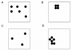
17. Which two of the following four boxes has the highest density of dots?
A. A, B B. B, C C. C, D D. A, D E. None of the above |
D. a,d
|
|
|
18. Which two have the highest concentration of dots?
A. A, C B. B, D C. A, B D. C, D E. None of the above |
b. B and D
|
|
|
19. An area distinguished by one or more unique characteristics is a _______
A. biome. B. region. C, space. D. landscape. E. uniform unit. |
region
|
|
|
20. The science of making maps is
A. geology. B. demography. C. cartography. D. topography. E. geomorphology. |
cartography
|
|
|
21. Scale is
A. the system used by geographers to transfer locations from a globe to a map. B. the extent of spread of a phenomenon over a given area. C. the method used to measure the impact of an event on the physical environment. D. the difference in elevation between two points in an area. E. the relationship between the length of an object on a map and that feature on the landscape. |
E. the relationship between the length of an object on a map and that feature on the landscape.
|
|
|
22. 1:24,000 is an example of what kind of scale?
A. bar line B. fractional scale C. graphic scale D. written scale E. None of the above |
b. fractional scale
|
|
|
23. A system for transferring locations from a globe to a flat map is
A. distribution. B. interruption. C. projection. D. distortion. E. scale. |
c. projection
|
|
|
24. A computer system that stores, organizes, retrieves, analyzes, and displays geographic data is
A. GIAS B. GIS. C. GPS. D. remote sensing. E. USGS. |
b. GIS
|
|
|
25. The name given to a portion of Earth's surface is known as
A. location. B. place C. site. D. situation. E. toponym. |
e. toponym
|
|
|
26. The concept that the distribution of one phenomenon is scientifically related to the location of other phenomena is
A. regional analysis. B. regional association C. spatial analysis. D. spatial association. E. spatial distribution. |
d. spatial association
|
|
|
27. The arrangement of a phenomenon across Earth's surface is
A. regional association B. regional analysis. C. spatial analysis. D. spatial association. E. spatial distribution. |
e. spatial distribution
|
|
|
28. The frequency of something within a given unit of area is
A. concentration. B. density. C. distribution. D. spacing E. pattern. |
b. density
|
|
|
29. The spread of something over a given study area is
A. spacing B. concentration. C. density. D. distribution. E. pattern. |
d. distribution
|
|
|
30. The spatial distribution created by the U.S. Land Ordinance of 1785 is an example of
A. concentration. B. density. C. distribution. D. pattern. E. spacing |
d. pattern
|
|
|
31. The population of the United States is approximately 270 million, and the land area is approximately 10 million square kilometers. The arithmetic density of the United States is approximately
A. 270 square kilometers per person. B. 27 square kilometers per person C. 27 persons per square kilometer. D. 0.04 square kilometers per person. E. 0.04 persons per square kilometer. |
c. 27 persons per square kilometer
|
|
|
32. Which is not a form of expansion diffusion?
A. contagious B. hierarchical C. relocation D. stimulus E. All of the Above |
c. relocation
|
|
|
33. Economic development through international trade is an example of what type of diffusion?
A. contagious B. hierarchical C. relocation D. stimulus E. All of the Above |
b. hierarchical
|
|
|
****34. If a group of people migrated from Papua New Guinea to North America and adopted Western cultural habits, this would be an example of
A. acculturation. B. cargo cult. C. hierarchical diffusion D. diffusion. E. sequent occupance |
c. hierarchical diffusion
|
|
|
35. According to environmental determinism,
A. the physical environment does not determine social development. B. the physical environment forces certain social development. C. the physical environment sets limits on human actions. D. people can adjust to the physical environment. E. people can choose a course of action from many alternatives offered by the physical environment |
B. the physical environment forces certain social develop
|
|
|
36. Which of the following types of maps use isolines to convey change over space?
A. cartograms B. azimuthal projections C. topographic maps D. mental maps E. location charts |
c. topographic maps
|
|
|
37. Jenny’s Grandma emigrated from Dublin to New York, and the journey took her 4 days by boat. Jenny’s brother migrated from New York to Dublin, but his journey only took 7 hours by plane. This is an example of:
A. least-cost travel B. transferability C. topological space D. demographics E. time-space convergence |
e. time space convergence
|
|
|
38. Which of the following statements best describes the subject matter of cultural ecology?
A. flows of energy and materials in an urban region. B. interactions between ethnicities in a stateless nation C. human-modified natural landscapes. D. interactions between human societies and the physical environment. E. characteristics of geographic regions |
D. interactions between human societies and the physical environment.
|
|
|
39. No map is an accurate representation of the earth’s surface because
A. the distance decay effect prevents accurate representation. B. all maps are geoids C. a sphere cannot be projected onto a flat surface without distortion D. all maps are mental maps E. all maps are, to some extent, preference maps |
C. a sphere cannot be projected onto a flat surface without distortion
|
|
|
40. Seoul, South Korea can be found at 37 00 N, 127 30 E. These coordinates describe Seoul’s
A. orientation B. absolute location C. cartographic position D. Mercator Projection E. situation |
b. absolute location
|
|
|
41. A functional region differs from other region types in that it
A. has no center B. has a focal point or node C. has political boundaries D. has an absolute location E. obeys the rank-size rule |
b. focal point or node
|
|
|
42. The initial spread of HIV between large cosmopolitan cities (e.g. Miami, San Francisco, New York) exemplifies which type of diffusion?
A. longitudinal B. stimulus C. hierarchical D. contagious E. relocation |
c. hierarchical
|
|
|
43. You have two maps. One shows population density by state, other shows population density by county, and the two reveal entirely different patterns. This is an example of
A. preference B. map projection C. scale of inquiry D. a mental map E. visualization |
c. scale of inquiry
|
|
|
44. The Far West and the Deep South are
A. formal regions B. nodal regions C. physical regions D. vernacular regions E. functional regions |
d. vernacular regions
|
|
|
45. Which of the following statements illustrates environmental determinism?
A. Siberia is rich in mineral resources B. in the Philippines, Luzon rice farmers terrace the hill slopes C. Chile is a mountainous country D. the natives are restless because of the hot season E. when it gets hot in Texas, some people turn on air conditioners |
D. the natives are restless because of the hot season
|